

Stavanger will drown, Denmark’s land mass will shrink and Stockholm won’t be accessible by boat. New calculations of sea level changes and land uplift show major changes in Scandinavia’s landscape over the next thousands of years.
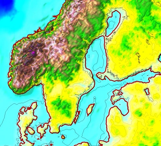 Figure 1. Calculated new coastal line (red line) by the time the uplift ends. The current coastal line is shown by the black line.
- The Oslo Fjord will be significantly smaller than today.
- The Trondheim Fjord has become a lake.
- Large parts of Stavanger will drown due to rising sea levels and subsidence of the solid earth.
- Stockholm will be much further away from the Baltic Sea, and will probably no longer be accessible by boat.
- The Vaasa area in Finland (Gulf of Bothnia) will be landlocked with Sweden.
- The ferry between Finland and Åland can be closed; Åland has become part of the mainland.
- The large islands in Estonia (Saarema and Hiiumaa) will cease to be islands and become part of the mainland.
- Denmark is sharply reduced in area.
New calculations of sea level change and land uplift shows that this could become a reality in a few thousand years.
Original article from 2016 (in Norwegian) by Willy Fjeldskaar and Aleksey Amantov
Up to 40 meters elevation remains
The ice over Scandinavia was during the last ice age at its thickest a couple of kilometers thick and pushed the land masses down. During the last ice age, the ice sheet reached its greatest extent about 20,000 years before the present (LGM; Last Glacial Maximum) and had melted away 8,500 years ago.
Uplift started when the ice really started to melt after LGM and today, the largest uplift rates are to be found in the Gulf of Bothnia.
We have previously calculated the remaining future land uplift. The remaining increase is the difference between the isostatic state of equilibrium and the increase that has taken place from LGM until today.
The calculations show that in the central part of the previously icy area (Bottenviken) there are about 40 meters left before the land uplift is completed.
The sea level is also changing
The focus of this article is the changes in the landscape until the uplift is completed. What remains of isostatic movements, in addition to glacial isostasy, is the remaining hydro-isostatic subsidence after the Baltic Sea experienced a large change in sea level at the end of the ice age.
The landscape will also be affected by changes in sea level over the next thousands of years. We have assumed here that this can be 3 – 4 meters. Isostatic response of this sea level change is not included.
Estimated impact of isostasy and eustasy (sea level change) on the landscape is shown in the figure above.
We must be careful not to draw too far-reaching conclusions, because the calculations are based on relatively low resolution, which is not optimal when finding more local changes.
But if we, despite this, still want to draw some conclusions, it will be something like the list at the top of the article.
However, this land uplift will be far in the future. It will take several thousand years before isostatic equilibrium is reached and land uplift is over.
Will it be as the calculations show? Qui vivra verra – he who lives, sees.
Reference
Amantov, A. & W. Fjeldskaar, 2016. Ice age and coastal adaptions. Proceedings for EMECS’11 SeaCoasts XXVI, St. Petersburg, Russia.
")