

Using UAVs allows us to survey areas that would be difficult or dangerous to perform ground surveys on, such as glaciers or unstable slopes. This photo is taken at Fjallsjökull, an outlet from Vatnajökull, the largest ice cap in Iceland. Photo: UiB
Denne saken ble først publisert i GEO 2024. Bestill ditt eksemplar her
Earth scientists have always been fascinated by space and time – understanding where something happens and when it takes place. This curiosity spans from tracking ancient glaciers to modeling interactions between the atmosphere and the ocean. As the planet changes, we look for new tools and methods to monitor and understand these shifts.
For the past quarter of a century, the Earth has continuously been orbited by hundreds of Earth-observation satellites. These satellites can detect and measure changes to our planet’s surface in increasingly fine detail and permit scientists to study how the planet’s surface has changed over the last half-century.
However, satellite imagery is dependent on clear skies to survey, the timing of acquisitions is not flexible, and high-resolution satellite imagery can be expensive. Uncrewed Aerial Vehicles (UAVs), commonly referred to as drones have rapidly become essential equipment for any earth scientist and allow detailed, on-demand surveys for small areas.
UAVs are not necessarily new, however over the last decade the technology has evolved to a point where flying a UAV is no more demanding than playing a video game.
Modern, off-the-shelf drones are capable of measuring the oncoming wind and accounting for it when flying, detecting and avoiding obstacles, and adjusting the flying height based on variable topography. UAVs are also affordable, with the cameras on even the basic models typically being sufficient for performing surveys that can match LiDAR datasets in terms of their spatial resolution.
As such UAVs are no longer in the domain of remote sensing scientists but are commonly used by a variety of earth scientists, geologists, ecologists, and geographers, allowing them to digitally capture their field areas which can later be used to characterize landforms and landscapes, and to assess changes over time.
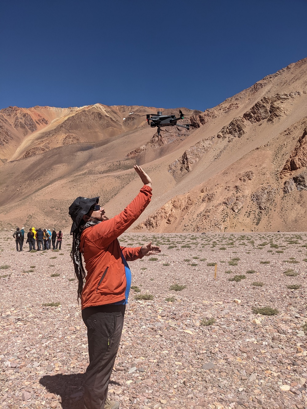
UAVs come in a range of models at a range of prices. For many, the most practical UAV type is a quadcopter such as the DJI Mavic series. These are typically lightweight and small enough to fit in a backpack, however, the area they can survey is typically limited, and it is harder to customize the camera onboard the UAV.
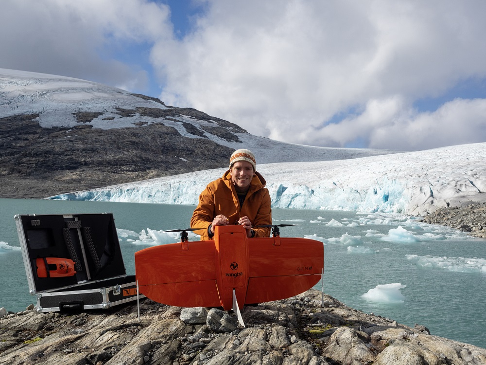
The University of Bergen has recently purchased a Wingtra One drone which is a fixed-wing model that flies faster than a quadcopter and can support a range of RGB, multispectral, and thermal cameras. This has allowed us to cover much larger areas than our quadcopters can, however, the drone is less portable and considerably more expensive to buy.
While some use UAVs for inspecting their field areas, the real strength of UAV analyses comes from using photogrammetry to turn a series of overlapping aerial photographs into rich 3D models.
To understand how photogrammetry works, you can imagine you are looking out of the window on a moving train. An object that is far away, such as a church at the top of a hill, is going to appear to be moving slower than a tree near the train track. Photogrammetry uses the same principle, and by measuring the relative distortion of objects from one photograph to another, it can convert the photographs taken by the UAV into high-resolution 3D models.
For the automated matching of images to work well, it is essential to have good image contrast that can be readily identified. This means that one can typically expect to get more robust 3D models from a UAV dataset of a rock outcrop than a dataset over snow and ice where it can be more challenging to have distinct features over the entire image.
The Department of Earth Science at the University of Bergen has been keen to integrate modern geomatic methods such as UAVs into the curriculum to ensure that our students are equally adept in performing high-resolution surveying as they are in other geological methods such as quaternary mapping or logging cores.
This past year our students have been using UAVs in various cryospheric applications, including mapping the surface of complex ice-debris landforms in the High Andes of Northern Chile and deriving snow depth measurements on the Hardangervidda plateau.
In each case, we have tasked the students with planning the UAV missions and determining all the necessary flight parameters, each of which determines the output resolution of the final point cloud. Flying a drone higher will allow you to cover a larger area, but the output resolution will be lower.
For more complex terrain, it can be an advantage to have a higher overlap between images or to take oblique photographs. Additionally, the students have been flying in challenging conditions, operating UAVs at elevations over 5,000 m a.s.l., temperatures below -20 oC while having to contend with variable and occasionally gusting wind conditions.
Once the images have been collected, processing is relatively automated. A variety of open-source (MicMac, OpenDroneMap) and propriety software (Metashape, Pix4D) exists for photogrammetric processing which produces high-resolution 3D terrain models and image mosaics that can be used for a variety of purposes such as examining field areas virtually, performing detailed mapping, or for assessing changes over time, for example looking at glacier thinning rates, or determining the depth of snow cover.
We’ve observed a growing interest among students in drone technology. They understand that mastering UAVs is a valuable skill, whether they aim for a career in research, government, or industry. In our courses, we emphasize the importance of integrating new technologies with foundational geological knowledge, preparing students for the evolving landscape of geosciences.
BENJAMIN AUBREY ROBSON
Associate professor, remote sensing and geomatics, UiB
")