

Denne artikkelen ble skrevet av geoforskning.no for Dansk Geologisk Forening.
At the Technical University of Denmark (DTU), located 15 kilometres north of the city centre of Copenhagen, close to 600 geoscientists brightened the cold and dark January days as they came together to share new knowledge, results and opinions.
Without a doubt, the Geological Society of Denmark together with DTU proved to be a wonderful host for the Nordic Geological Winter Meeting.
The first day of the conference was kicked off by a plenary talk by Kristin Rangnes. She is the director of Geo Norvegica UNESCO Global Geopark.
 Kristin Rangnes. Foto: Ronny Setså
– The geopark concept was initiated the 1990s. But there are still many people, including geoscientists, that are not aware of what it is all about, Rangnes said.
Despite the name, geoparks isn’t just about the geology. The ecological and cultural aspects are of equal importance.
The aim of the parks is to protect and promote important sites through sustainable development. In 2017, 127 geoparks are found in a total of 36 countries. Many are located in Europe and China. The Nordic countries however, lag behind, according to Rangnes.
– We have some parks established, but Sweden has none. I would therefore welcome future initiatives both from these countries in general, as well as Sweden in particular.
In 2015, the geoparks received what could be called official UNESCO status, meaning they are equally important as the well-known world heritage sites.
Another plenary talk was held by Sune Nielsen (Woods Hole Oceanographic Institution, USA) the following day.
 Sune Nielsen. Foto: Ronny Setså
Nielsen took a deep dive into the processes within subduction zones.
– There are basically two models for how and when material melts and rises towards the surface from these zones, Nielsen said.
During his lecture, Nielsen argued for the lesser known model, the mélange model, meaning that the subdued material (mantle, sediments and oceanic crust) is mixed before melting and upwelling, resulting in a different understanding of the subduction and following volcanic processes.
A tale of two slides
During 2017, there were two gravity movements that gathered more attention than others in the Nordic countries. One of them took place in Greenland, while the other, despite hard work and a lot of patience, actually never happened…
The first incident is the June 21st tsunamigenic landslide in the Karrat Fjord in western Greenland. The slide, which happened in the middle of the night, created large waves that devastated a remote settlement (Nuugaatsiaq).
According to some scientists, the tsunami was one of the tallest in recorded history. It even generated a seismic signal suggesting a magnitude 4.1 earthquake.
Senior scientist Pierpaolo Guarnieri at GEUS presented some geological observations of the landslide.
 Pierpaolo Guarnieri. Foto: Ronny Setså
– Luckily, we had surveyed the area in 2015. After the slide, we could go back and observe the differences along the fjord sides, Guarnieri said.
By comparing the photos and digital terrain models from 2015 with the newly acquired ones, the geologists came to the conclusion that the slide had a rock volume of approximately 41 million cubic meters.
– By studying the hillsides with regards to transported boulders and washing of material, we have estimated a tsunami height of up to 75 meters, depending on the slopes of the hillsides along the fjord.
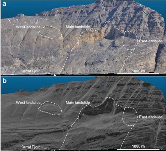 Photo (upper image) and 3D reconstruction (lower image) shows the landslide scar. Source: Gauthier et al., 2017.
The second incident, as previously mentioned, has yet to occur. Since 2014, the stubborn mountain Mannen (Norwegian: The man) in the western part of Norway has been monitored and shows quite a lot of movement, but has yet to fall.
Last year, the Norwegian Water Resources and Energy Directorate (NVE) gave green light for the scientists to pump water down into the cracks of the mountain in order to speed up to rock fall process.
During his presentation, Lars Harald Blikra at NVE confirmed that the artificial supply of water did increase the rate of movement, but it was not sufficient. The man still stands, troubling the lives of those in the local community.
During the same session, key note speaker Ueli Gruner presented a similar case from Switzerland where blastings was used in an attempt to take down an unstable mountain block.
It is however, according to Blikra, not feasible for Norway to try out a similar approach using explosives due to geological complexities and the risk of disturbing a larger part of the mountain. But more water will most likely be tried out in 2018.
Largest in human history?
Svend Funder (KU) and Adam Garde (GEUS) presented some interesting results from the north-western parts of Greenland. Buried deep under the ice sheet, they believe to have found the remnants of a large and rather young meteorite impact.
In fact, the crater structure may be so young that the bedrock still has excess heat, melting the ice sheet from below.
According to the two scientists, the proposed meteorite crater measure 31 kilometres in diameter and 400 meters in depth, potentially making it the largest created in human history.
The age is still not clear, but preliminary analyses indicate it is at least 11 700 and up to 38 000 years old.
So far, they have collected and analysed one sample downstream of the impact structure.
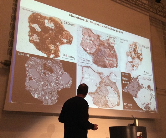 Adam Garde presents some of the evidence of a possible meteorite impact. Photo: Ronny Setså
– We have found several evidences that this is in fact an impact crater, said Garde, referencing the findings of shocked minerals in addition to the clear, round structure observed in radar data.
The latest findings are expected to be published soon, as they are currently under review.
An unique achievement in the Arctic Ocean
With good reason, keynote speaker Yngve Kristoffersen (University of Bergen) gathered many attendees in his presentation on marginal plateaus north of Svalbard and Greenland.
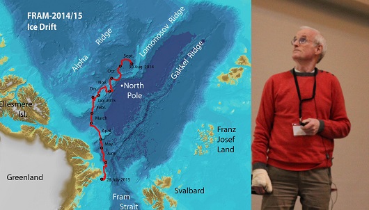 The red line shows the route along which Kristoffersen and Tholfsen collected a huge amount of scientific data over the course of a year. Illustration: FRAM-2014/2015. Photo: Ronny Setså
For those who are unaware, Kristoffersen is considered somewhat of a modern polar hero in Norway. Along with his colleague Audun Tholfsen, he spent a full year (2014-2015) drifting on an ice flake in the Arctic Ocean, collecting new data from one of the world’s least mapped areas.
In harsh weather conditions and periods of total darkness, the two explorers managed to collect geological, geophysical, meteorological and oceanographic data that the scientific community will spend years analysing.
We encourage everyone to read more on Kristoffersen’s endeavours, for instance on Geoforskning.no. Did we mention that he was 72 years old when he started the journey? And that he single-handedly obtained the project financing without collecting salary?
An the award goes to…
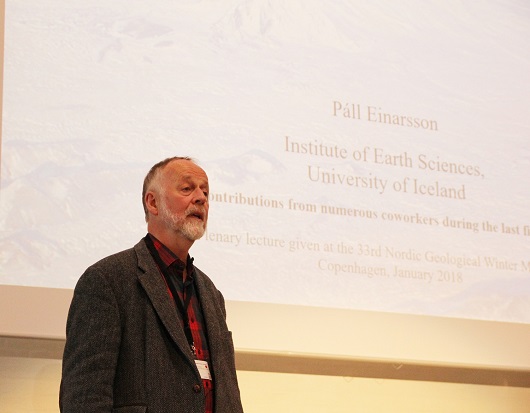
Páll Einarsson! The geophysicist and retired professor at the University of Iceland won this year’s Nordic Geoscientist Award.
 Páll Einarsson. Photo: Ronny Setså
Einarsson received the award for his contributions in seismology and geodesy in the work of understanding magmatic and tectonic processes along the plate boundaries of Iceland and the North Atlantic.
In his plenary speech, Einarsson gave the audience an insight into the current status of the active and dormant volcanoes on Iceland, as well as whether it is possible to forecast and send out warnings ahead of eruptions.
According to statistics, about two thirds of the eruptions since the 1970’s have been anticipated and warnings sent out prior to eruptions. The precursor time (early earthquakes to eruptions on surface) have varied from 15 minutes to 13 days.
The Best Student Poster was awarded to Anders Dahlin (Denmark) and Katrine Mo (Norway). Congratulations!
LES OGSÅ: Pris til NTNU-student
")