

Her kan du lese siste oppdateringer fra JOIDES Resolution som frem til 6. oktober skal bore opptil ni vitenskapelige hull i vulkanprovinsen i Norskehavet.
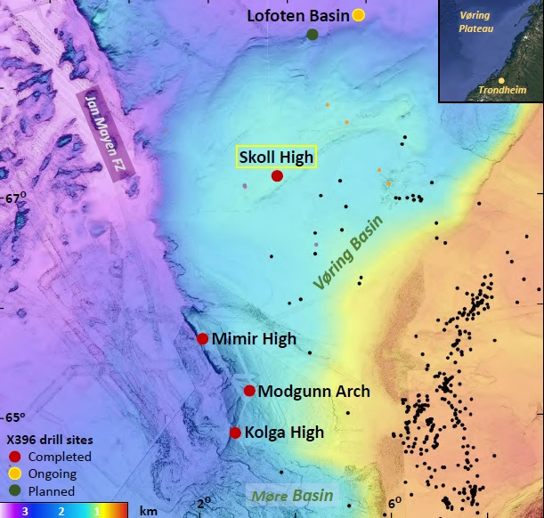 Boreskipet har begynt boringen ved Lofotenbassenget i nord. Batymetrisk kart over den midtnorske marginen som viser borelokalitetene til IODP på Vøringplatået. Figur: Christian Berndt
Toktet heter Mid-Norwegian Continental Margin Magmatism og utføres av det internasjonale boreprogrammet International Ocean Discovery Program (IODP).
Toktet har som formål å forstå hvordan den store vulkanprovinsen i det nordøstlige Atlanterhavet ble dannet, og hvordan vulkanismen førte til global oppvarming for 56 millioner år siden.
Flere norske fagmiljøer har bidratt til eller er med på toktet, deriblant CEED/UiO, UNIS, VBPR, NCCS, OD og CAGE/UiT.
Les mer om toktet og deltakerne her: Kommer til Norge
Vulkanske bergarter og en klimagåte: Skal bore ni vitenskapelige hull
English version: Drilling into old lava
Siste oppdateringer
21. september
Co-Chief Scientist Sverre Planke oppdaterer:
Da er vi ferdige med å bore hull 18 (U1573A) på ekspedisjonen, og jeg er veldig fornøyd med resultatene. Vi boret nesten 60 meter ned i vulkansk havbunnsskorpe i Lofotenbassenget. Vanndypet her var på hele 3167 meter, mens boredypet ble 441 meter.
Nå er det litt uvær på gang, så vi seiler sørover. Med unntak av noen timer med borestans i forrige uke, så er dette første gang på toktet vi har hatt nedetid.
Vi har fremdeles to uker igjen før vi skal være tilbake i Reykjavik. Planen er å dra tilbake til Lofotenbassenget når været bedrer seg. Målet er da å bore ned i en c. 54 millioner år gammel vulkan, en såkalt «Outer High».
Vindsituasjonen 21. september. Boreskipet er markert med grønn sirkel.
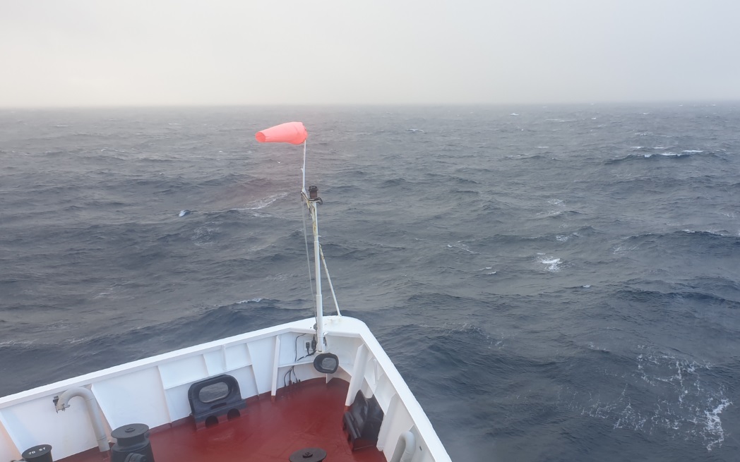 Fortsatt fine forhold i Norskehavet, men vindstyrken tiltar. Foto: Sverre Planke
Kloken 12.15 onsdag sender JOIDES Resolution direkte fra skipet via Facebook. Se sendingen her
20. september
Co-Chief Scientist Sverre Planke oppdaterer:
Boringene på Skollhøyden gikk veldig bra, og vi fikk boret fire hull. Vi holder nå på å bore på 3 km dypt vann i Lofotenbassenget.
Det ser ut til at været blir dårligere framover, så det blir spennende å se hva vi får til her (og på resten av toktet).
Per 19. september har JOIDES Resolution boret 3 065 meter og hentet 1 665 meter kjerneprøver. Totalt har de fullført 17 hull.
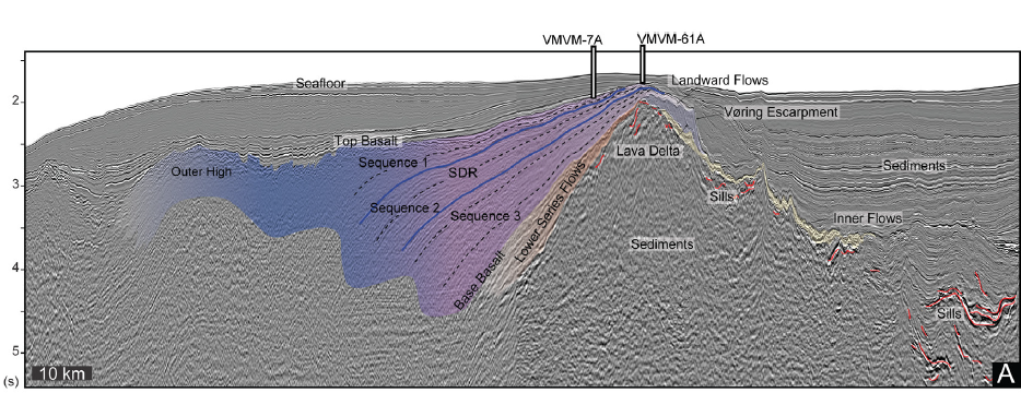
Vøringmarginen har siden 1970-tallet vært et globalt typeområde for vulkanske riftmarginer. De vulkanske bergartene på denne marginen er kun dekket av et tynt lag med sedimenter, og vi har derfor kunnet kjernebore en rekke forskjellige vulkanske sekvenser på toktet.
På Skollhøyden har målet vært å ta kjerneprøver av to forskjellige vulkanske sekvenser; såkalte indre sjøveis hellende reflektorer (Inner SDR) og underliggende lavasekvenser (Landward Flows).
Tidligere på toktet har vi boret gjennom disse lavasekvensene på Kolgahøyden der vi fant lavastrømmer og forvitrede granitter.
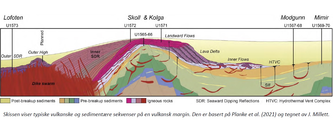
På Skollhøyden har forskerne boret to hull som til sammen har gtt 590 meter med kjerner som består av lavastrømmer, interbasalt-sedimenter og slamstein og løsmasser.
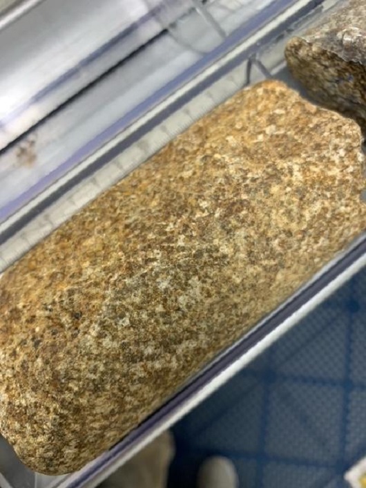
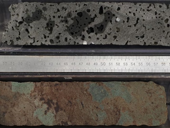 Blærebasalt og interbasalt-sedimenter hentet fra Skollhøyden. Foto: Sverre Planke, IODP JRSO
 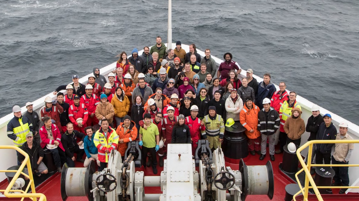 Gruppebilde av (nesten) alle ombord boreskipet JOIDES Resolution tatt søndag 19. september. Foto: IODP JRSO
16. september
Co-Chief Scientist Sverre Planke forteller at boringen på Skollhøyden fortsetter jevnt og trutt.
De er snart ferdig med det fjerde og siste borehullet. Deretter seiler de til Lofotenbassenget for å bore i osean skorpe.
Hver uke publiserer boreskipet bilder fra uken som gikk. Her er et utvalg:
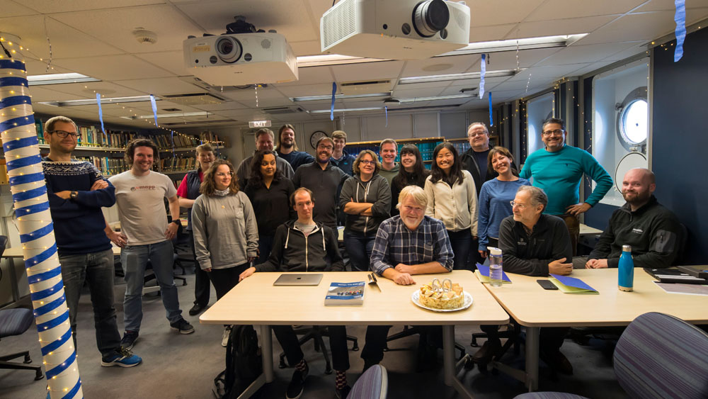 Det ble feiret med kake da Co-Chief Scientist Sverre Planke fylte 60 år. Foto: Sandra Herrmann, IODP JRSO
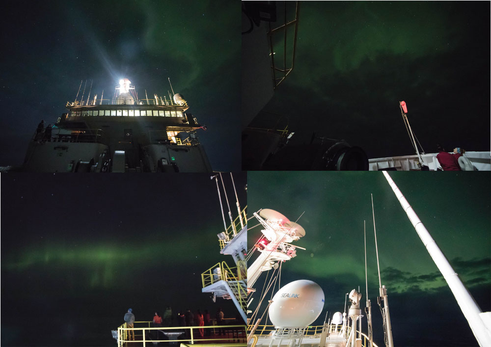 Observasjon av nordlys er et selvfølgelig høydepunkt. Foto: Sandra Herrmann, IODP JRSO
 Nye kjerner har kommet på dekk. Foto: Sandra Herrmann, IODP JRSO
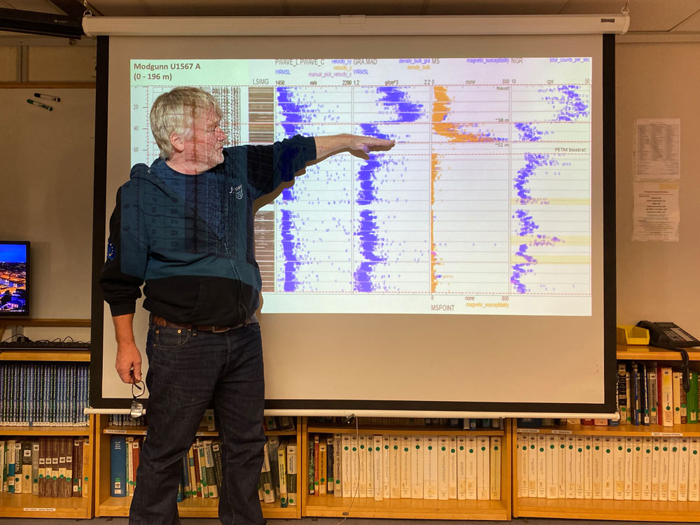 Co-Chief Scientist Sverre Planke presenterer data fra et borehull på Modgunn som ble boret i slutten av august. Foto: Carlos Alvarez Zarikian, IODP JRSO
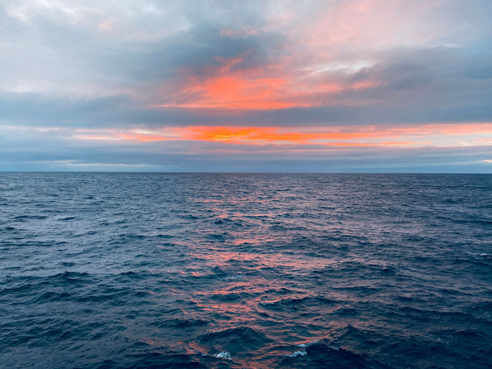 Foto: Sayantani Chatterjee & IODP
15. september
The basalts offshore Norway that once likely caused a climate crisis may act as future reservoirs for carbon storage.
Read the article by Peter Betlem, John Millett, Sverre Planke and Christian Berndt here
Location:
Hole U1572A (67°19.8477′N, 3°37.1620′E; water depth 1210.5 mbsl; proposed Site VMVM-07A)
Hole U1572B (67°19.9178′N, 3°37.0570′E; water depth 1206.5 mbsl; proposed Site VMVM-07A)
Science Update: After the logging equipment was stored and secured, we recovered the drill string, and inspected and laid out all the components while moving the ship 147 m west in DP mode to the location of Hole U1572B. At 0415 h, we began to assemble the outer APC/XCB core barrel and the BHA while deploying the drill string down to the seafloor, filling the pipe with seawater every 20 stands. At 0845 h, we picked up the top drive and spaced out the bit above the seafloor in preparation to spud Hole U1572B.
We fired the mudline core, recovering 6.78 m of sediment, and spudded Hole U1572B at 1015 h. Based on core recovery, we determined the water depth to be 1206.5 mbsl. We continued coring with the APC system to 149.3 mbsf when 90,000 lbs of overpull were required to release Core U1572B-16H from the formation. We switched to the HLAPC and continued coring. Cores 17F to 23F advanced the hole to 182.1 mbsf by midnight. The total amount of core recovered today from Hole U1572B was 187.5 m (103%).
In the laboratories, we finished describing the last five cores from Hole U1572A and began measuring and describing cores from Hole U1572B. Cores U1572A-42R to 46R (301.3–330.5 mbsf) consist of aphyric basalt with varying vesicularity. Cores U1572B-1H to 4H (0–35.3 mbsf) consist of interbedded clay and sandy-rich clay. The micropaleontology team estimated a middle Eocene age for the base of Core U1572B-19F, based on biosiliceous and organic microfossils.
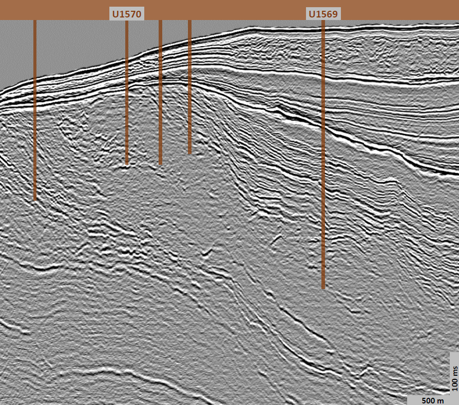
The scientists continued to analyze data from Sites U1570, U1571, and U1572, and prepared site reports.
14. september
Location: Hole U1572A (67°19.8477′N, 3°37.1620′E; water depth 1210.5 mbsl; proposed Site VMVM-07A)
Science Update: We completed RCB coring in Hole U1572A with Cores U1572A-42R to 46R, advancing the hole to a final depth of 330.5 mbsf. The total amount of core recovered from Hole U1572A was 139.53 m (42%).
Following the retrieval of the last core at 1240 h, we secured the coring tools and began preparations for wireline logging. We conducted a 50-barrel high viscosity mud sweep to clean the hole and then lowered the (RST) and released the bit at the bottom of the hole. We displaced the hole with 110 barrels of 10.5 ppg mud, raised the drill string to set the end of the pipe at 81 mbsf for logging, and further displaced the hole from the end of the pipe to the top of the hole with 20 barrels of 10.5 ppg mud.
The triple combo tool string was rigged up by 1900 h and deployed, but was only able to reach 256 mbsf (74.5 m off bottom). We conducted an upward pass and could not complete a second pass as the hole had deteriorated. Logging activities were suspended, and the tool was recovered safely back onboard at 2330 h. We spent the rest of the day rigging down the logging equipment.
In the laboratories, we continued measuring and describing cores from Hole U1572A. Cores U1572A-28R to 41R mainly consist of basalt and interbasaltic sediment. The basalt is mainly hypocrystalline aphyric basalt, occasionally with trace copper, and rare sparsely plagioclase phyric basalt. The interbasaltic sediment is dark greenish gray to dusky red to black volcaniclastic sandstone or claystone likely from in situ breakdown of basalt.
The scientists continued to analyze data from Sites U1570, U1571, and U1572, and prepared site reports.
13. september
Fra skipets Twitter-konto:
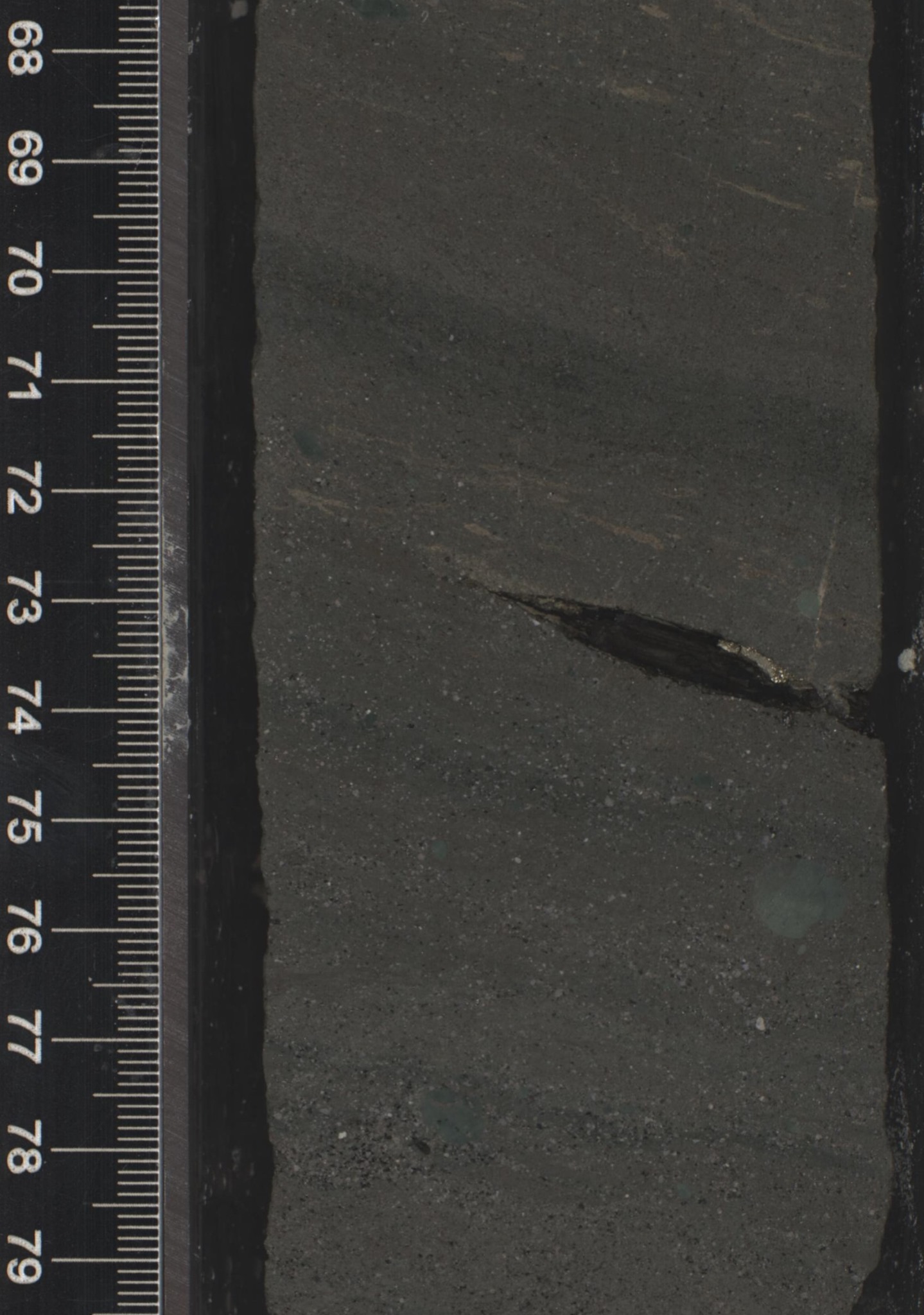
I denne kjerneprøven av eocen alder (noe yngre enn 56 millioner år) ser vi ett mørkt fragment som er en bit av et tre. På toppen av fragmentet befinner det seg pyritt (jernsulfid) som trolig ble dannet som følge av oksidering av trefragmentet kort tid etter at fragmentet ble begravd i leiren.
Slikt organisk material kan sammen med mikrofossiler hjelpe forskerne å datere en prøve og få innsikt i miljøet på den tiden sedimentene ble avsatt. Plantematerial kan videre mer spesifikt fortelle forskerne hvor mye CO2 som var i atmosfæren da planten vokste.
Foto: Weimu Xu
Location: Hole U1572A (67°19.8477′N, 3°37.1620′E; water depth 1210.5 mbsl; proposed Site VMVM-07A)
Science Update: We continued RCB coring in Hole U1572A from 242.2 to 296.5 mbsf (Cores U1572A-30R to 41R). Total core recovered for today was 44 m (75%).
In the laboratories, we continued measuring and describing cores from Hole U1572A. Cores 23R to 27R consist of a downhole succession of very dark greenish gray basaltic andesite to dark gray aphyric basalt with intervals of sparsely plagioclase phyric basalt and occasional interbedded intrabasaltic sediment.
Palynological analyses confirmed the presence of abundant remains of the freshwater fern Azolla in Eocene sediment above the basalt. Interstitial water (IW) analysis showed very low alkalinity values in the porewater of intrabasaltic sediment layers.
The scientists continued to analyze samples and data from Sites U1570, U1571, and U1572, and prepared site reports.
12. september
Co-Chief Scientist Sverre Planke (VBPR/CEED) forteller:
Mikrofossiler i gamle sedimenter fra Mimirhøyden og Vøringrandhøyden er lite deformert da de aldri har vært dypt begravd eller utsatt for høy varme. Bildet under viser noen kiselalger av paleogen (66 – 23 millioner år) alder.
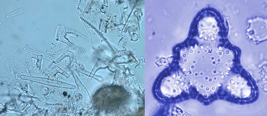 Foto: Reed Scherer
Bildet under: Morgan Jones (CEED), her opptatt med å ta vannprøver fra sedimentkjernene. Disse prøvene blir siden analysert i kjemilaben.
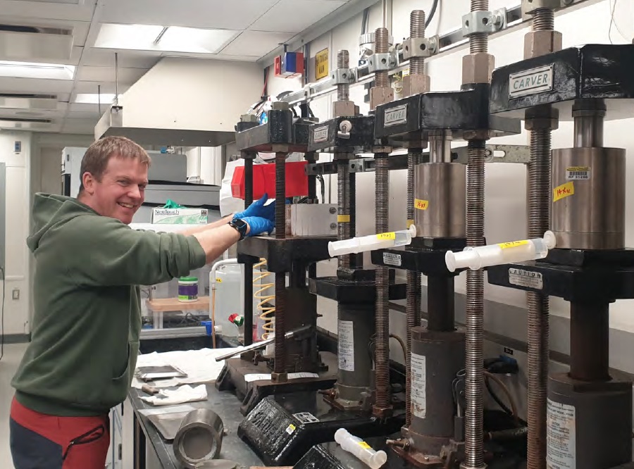 Foto: Sverre Planke
Location: Hole U1572A (67°19.8477′N, 3°37.1620′E; water depth 1210.5 mbsl; proposed Site VMVM-07A)
Science Update: Rotary coring continued throughout the day with Cores U1572A-5R to 29R, deepening the hole from 38.5 mbsf to 242.2 mbsf. Basement was reached at 204 mbsf in Core 22R. Core recovery of the sedimentary succession was 46.44 m (22%). Core recovery throughout the basement section was 27.65 m (71%).
In the laboratories, we finished measuring and describing cores from Hole U1571B and began to measure and describe cores from Hole U1572A. Cores U1571B-15X to 21X consist of dark brown volcaniclastic claystone with varying sand content and parallel laminations. We observed hyaloclastite and aphyric basalt interbedded within the sediment.
Cores U1572A-1R to 11R consist of brown to gray to very dark gray clay with silt and some intervals of calcareous nannofossil ooze. Cores 12R to 13R consist of alternating ash-rich diatomite and diatom ooze. Cores 14R to 16R consist of alternating layers of radiolarian and diatom ooze and ash. Cores 17R to 21R consist of diatom-rich claystone and siltstone with ash. Core 22R contained sandstone and completely altered light gray andesite. Biostratigraphic and palynological analyses estimate an age of late early Eocene at the base of Core 21R.
The scientists continued to analyze samples and data from Sites U1570, U1571, and U1572, and prepared site reports.
11. september
Co-Chief Scientist Sverre Planke (VBPR/CEED) oppdaterer:
Det ble et flott nattskift på Skollhøyden. Nesten blikkstille hav, og noen hull i skydekket. Først fikk vi se nordlys ved midnatt, og så var det en flott soloppgang i dag tidlig. Da var Peter Betlem ute og fløy dronen.
Boringene går også bra; vi er snart ferdig med hull 2, og skal fortsette med et nytt hull i kveld for å finne mer basalter!
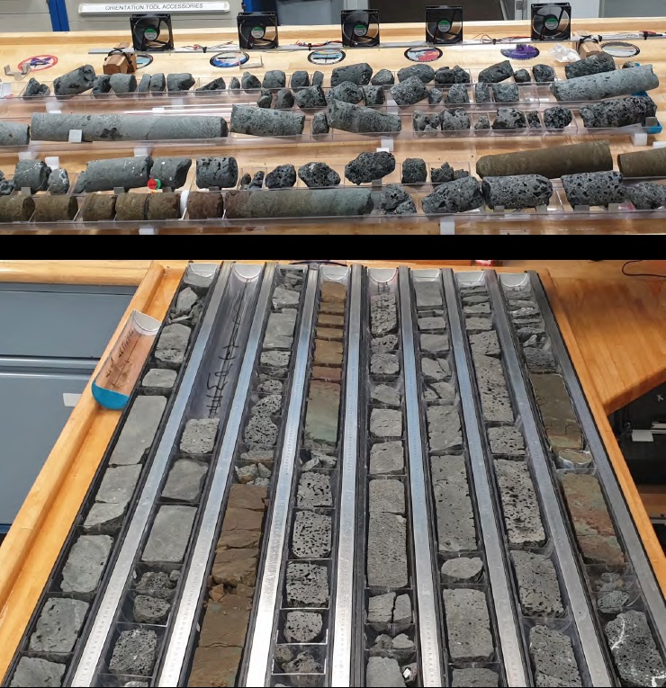 Foto: Sverre Planke
En god samling med basalt- og sedimentkjerner fra Skollhøyden. I det første hullet boret vi ca. 140 meter med basalter.
Basaltkjernene tørkes først, i dette tilfellet med noen provisoriske vifter da det vanlige tørkeskapet var fullt!
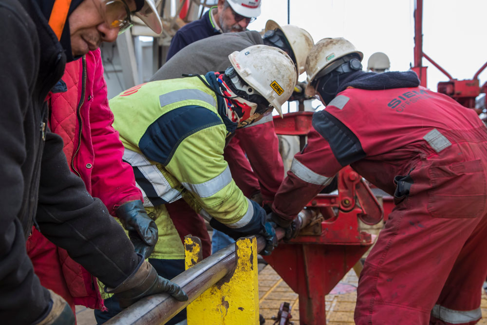
Deretter deles kjernene i to. Én halvdel beskrives og arkiveres, mens den andre blir tatt prøver av.
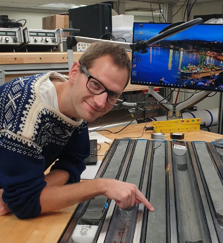 Foto: Sverre Planke
Andreas Bjørnestad fra Oljedirektoratet er norsk observatør på toktet. Han er geolog med bakgrunn fra Universitetet i Oslo.
På bildet studerer han massive basaltkjerner fra Skollhøyden i Norskehavet.
 Foto: Sverre Planke
Location:
Hole U1571B (67°18.4019′N, 3°44.2768′E; water depth 1205.3 mbsl; proposed Site VMVM-61A)
Hole U1572A (67°19.8477′N, 3°37.1620′E; water depth 1210.5 mbsl; proposed Site VMVM-07A)
Science Update: Today we completed coring operations at Site U1571 and began to RCB core at Site U1572.
At Site U1571, Cores U1571B-15X to 20X extended the hole from 120.3 mbsf to the final depth of 143.7 mbsf, with good recovery of the sediment-basement transition (68%). Total core recovered at Hole U1571B is 112.5 m (78%). At 1030 h, after recovery of the last core, we began pipe tripping operations, which continued during transit in DP mode to Site U1572 (proposed Site VMVM-07A). All APC/XCB BHA components were retrieved and stored, the rig’s traveling equipment was serviced, and a new RCB BHA was made up.
We arrived over the Site U1572 coordinates at 1600 h while deploying the drill string down to the seafloor. At 1930 h, with the end of the pipe at 1172.6 mbsl, we spaced out the bit and attempted to spud Hole U1572A based on a PDR depth of 1207.6 mbsl, but the core was retrieved empty. We added a single joint of pipe and dropped an RCB core barrel for a second attempt. This time we recovered 5 m of core, spudding Hole U1572A at 2145 h, and determining a water depth of 1210.5 mbsl. We continued RCB coring, retrieving Cores U1572A-2R to 4R (5 to 38.5 mbsf) with an overall recovery of 11 m (29%).
In the laboratories, we continued to measure and describe cores from Hole U1571B. Cores U1571B-4H to 9X consist of gray to greenish gray clay with increasing sand content with depth, Cores 10X to 12X mainly consist of greenish gray diatom ooze, and Cores 12X and 13X consist of an ash-rich clay overlying sand-rich claystone. Biostratigraphic markers estimate an age of 49 Ma for the base of this succession.
The scientists continued to analyze data from Sites U1570 and U1571 and prepared site reports.
10. september
Toktet i Norskehavet har vind i seilene. Jakten på kunnskap om fortidens vulkanske og klimatiske hendelser har så langt resultert i mer enn én kilometer med verdifulle vitenskapelige kjerneprøver.
Les vår oppsummering av ekspedisjonen på geo365.no: Går så det griner!
Location:
Hole U1571A (67°18.4017′N, 3°44.2496′E; water depth 1205.8 mbsl; proposed Site VMVM-61A)
Hole U1571B (67°18.4019′N, 3°44.2768′E; water depth 1205.3 mbsl; proposed Site VMVM-61A)
Science Update: The day began while deploying the UBI logging tool to the bottom of Hole U1571A. The tool string reached 237.9 mbsf and we conducted two upward passes collecting measurements through the open hole. The UBI was brought back to the surface at 0345 h and rigged down. After all logging equipment was stored and secured, we recovered the drill string, disassembled it, and inspected and laid out all the components by 0745 h. We made up the outer APC/XCB core barrel and the BHA and deployed the drill string back to the seafloor to begin Hole U15671B.
At 1215 h, we picked up the top drive and the drilling knobbies, spaced out the bit above the seafloor, and shot the mudline core, recovering 5 m. Based on the core recovery, we determined the water depth to be 1205.3 mbsl. We continued coring to APC refusal, which was reached at 57.2 mbsf (Core U1571B-7H) at 1845 h. Then we switched to the XCB coring system and cored to 120.3 mbsf, recovering Core 14X by midnight. Total core recovered today from Hole U1571B was 37.9 m (60%).
In the laboratories, we finished measuring and describing cores from Hole U1571A and began to process cores from Hole U1571B. Cores U1571A-35R to 39R consist of aphyric basalt with sparsely plagioclase phyric basalt. Cores U1571B-1H-3H consist of yellowish brown to olive green clay with varying amounts of silt and sand.
The scientists continued to analyze data from Sites U1570 and U1571 and prepared site reports.
9. september
Co-Chief Scientist Sverre Planke (VBPR/CEED) forteller at boreskipet har fullført første borehull på Skollhøyden. Her ble det blant annet påtruffet en rekke lavastrømmer. Forskerne er også svært fornøyde med kjernene de hentet opp fra Mimirhøyden der PETM-intervallet og tidlig eocen ble påtruffet i flere borehull.
We have now completed the first basement hole on the Skoll High, drilling c. 135 m of basalt flows and interbedded sediments below c. 115 m of Cenozoic overburden sediments. Core recovery has been exceptionally good in the basalt interval, but less across the sediment-basement transition. We will now do wireline logging of the hole, followed by APC/XCB drilling of the sediment-basement transition to improve the recovery of this unit.
Location: Hole U1571A (67°18.4017′N, 3°44.2496′E; water depth 1205.8 mbsl; proposed Site VMVM-61A)
Science Update: We completed coring operations in Hole U1571A after recovering Cores U1571A-37R to 39R from 228.1 mbsf to a final depth of 247.6 mbsf. Total core recovery for Hole U1571A is 116.55 m (47%).
Following the retrieval of the last core at 0525 h, we cleaned the hole by pumping 50 barrels of high viscosity mud and then lowered the (RST) and released the bit at the bottom of the hole. We displaced the hole with 75 barrels of 10.5 ppg mud, raised the drill string, and set the end of the pipe at 87 mbsf in preparation for downhole logging. At 1000 h, we rigged up the triple combo tool string and lowered it to 246.9 mbsf. We made two passes through the open hole, recovered the logging tool, and rigged it down by 1400 h. We deployed the FMS-sonic tool and conducted two passes from 246.9 mbsf upwards.
After retrieving and rigging down the FMS-sonic tool at 1745 h, we lowered the drill pipe to the bottom of the hole, installed the circulation head, and circulated the hole with seawater in preparation for the deployment of the UBI tool. We raised the end of the pipe to 104.9 mbsf and, rigged up the UBI tool, and by midnight we were lowering the tool to the bottom of the hole.
In the laboratories, we continued to measure and describe cores from Hole U1571A. Cores U1571A-26R to 34R consist of aphyric basalt with sparsely plagioclase phyric basalt and few intervals of interbedded sediments.
The scientists continued to analyze data from Sites U1570 and U1571 and prepared site reports.
8. september
Forskerne på boreskipet avsluttet nylig boringene på Mimirhøyden. Resultatet ble 415 meter med kjerneprøver som omfatter paleocene og eocene sekvenser med innslag av vulkanske bergarter og askelag.
Les mer her: Boret «klokskapens brønn» etter 21 år
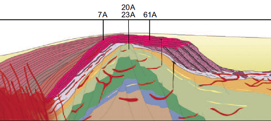
 Dette seismiske profilet viser de fem brønnene som er boret på Mimir-høyden. De består av bergarter av kritt, paleogen og kvartær alder og inneholder også magmatiske bergarter og askelag. Seismikken er høyoppløselig P-Cable 3D samlet av CAGE20-4-toktet i 2020. Kilde: Bünz med flere (2020)
Location: Hole U1571A (67°18.4017′N, 3°44.2496′E; water depth 1205.8 mbsl; proposed Site VMVM-61A)
Science Update: Today we continued RCB coring with half-length advances in Hole U1571A from Cores 24R at 164.9 mbsf to 36R at 228.1 mbsf. The total core recovered over this interval was 53.2 m (84%).
Cores U1571A-19R to 26R consist of sparsely to highly vesicular aphyric basalt. Interbasaltic volcanoclastic sediments are common.
The scientists continued to analyze data from Sites U1570 and U1571 and prepared site reports.
7. september
Location: Hole U1571A (67°18.4017′N, 3°44.2496′E; water depth 1205.8 mbsl; proposed Site VMVM-61A)
Science Update: Today we continued RCB coring Hole U1571A from Cores 14R at 121.1 mbsf to 23R at 164.9 mbsf. The total core recovered over this interval was 17.1 m (39%).
Cores U1571A-4R to 8R mainly consist of gray to very dark gray clay with silt. Cores U1571A-9R to 12R consist of dark brown to dark greenish gray clay with silt-rich and sand-rich intervals, and moderate bioturbation. Cores 13R to 18R mainly contain yellowish brown to reddish brown volcaniclastic sediments with occasional nodules alternating with aphyric basalt. The scientists continued to analyze data from Sites U1570 and U1571 and prepared site reports.
6. september
Boreskipet er på vei til Skollhøyden på den ytre delen av Vøringplatået. Her forventer forskerne å finne flere lavastrømmer fra ca. 125 meter under havbunnen.
Fem av de totalt ni boringene i toktet har som mål å hente prøver av lavastrømmer.
Lavastrømmene utgjør en del av de utbredte magmatiske bergartene som kan sees i sammenheng med dannelsen av Atlanterhavet for ca. 55 millioner år siden der store mengder magma (basalt) ble presset opp og avsatt på og under havbunnen mellom Norge og Grønland.
 Batymetrisk kart over den midtnorske marginen som viser borelokalitetene til IODP på Vøringplatået. Figur: Christian Berndt
 Borelokaliteten VMVM-61A på Skollhøyden har som formål å hente kjerneprøver av lavastrømmer. Illustrasjon: IODP Proposal Exp. 396
Location: Hole U1571A (67°18.4017′N, 3°44.2496′E; water depth 1205.8 mbsl; proposed Site VMVM-61A)
Science Update: We completed the 97 nmi transit to Site U1571 (proposed Site VMVM-61A) in 9.1 h, ending the sea passage at 0918 h. The vessel was switched to DP mode and the drill floor was cleared for operations at 0952 h. We made up and deployed the RCB BHA with a new bit and bit release system to 172 mbrf and then continued to lower the drill pipe to the seafloor while filling it with water every 20 stands. Beginning at 1330 h, we picked up the top drive and the drilling knobbies, spaced out the bit to just above the seafloor, and spudded Hole U1571A at 1500 h at 1205.8 mbsl. Rotary coring continued from the seafloor to 121.1 mbsf by midnight (Cores U1571A-1R to 13R). The total core recovered was 35 m (29%).
Cores U1571A-1R to 3R were measured and described. They contain grayish brown clay with silt and foraminifers. Biostratigraphic markers suggest a middle Miocene age for Cores 9R and 10R. The scientists continued to analyze data from Sites U1570 and U1571 and prepared site reports.
5. september
Location: Hole U1570D (65°49.8708′N, 1°59.1743′E; water depth 2207.7 mbsl; proposed Site VMVM-56A)
Science Update: Cores U1570D-24R to 28R extended the hole from 149.2 mbsf to the final depth of 200 mbsf at 0230 h. The total amount of core recovered at Hole U1570D was 50.5 m (25%). Following the retrieval of the last core, we conducted a 50-barrel high viscosity mud sweep to clean the hole, then ran the RST in on the coring line and released the RCB coring bit in the bottom of the hole. We ran the RST again to reposition the bit shifting sleeve back to the circulating position and displaced the hole with 65 barrels of 10.5 ppg mud. We set back the top drive and raised the end of the pipe to 76 mbsf in preparation for wireline logging. We rigged up the triple combo tool string and lowered it to 199.8 mbsf.
We conducted two upward passes of the open hole, collecting magnetic susceptibility, resistivity, density (with caliper), neutron porosity, temperature, and natural gamma radiation data. The triple combo tool string was recovered by 1220 h. We then rigged up and deployed the FMS-sonic tool and conducted two passes from 199.3 mbsf upwards. At 1800 h, after retrieving the FMS-sonic tool and rigging down all the logging equipment, the rig floor was cleared for pipe tripping operations. The drill pipe was picked up and stacked, the BHA drill collar stands were set back, and all core barrel components were broken down, inspected, and laid out. The rig floor was secured for transit at 2345 h. The thrusters were raised in preparation for departure and transit to the next site.
In the Core Laboratory, we measured and described the remaining cores from Hole U1570D. Cores U1570D-14R to 16R mainly consist of garnet-bearing dacite, with cordierite, pyrite, and graphite. Transitions between sediment and lava flows are present in part of this interval. Cores U1570D-17R to 19R mainly consist of very dark gray siltstone with clay with no bioturbation. Dewatering structures and pyrite are common.
Cores U1570D-20R to 28R contain very dark gray to dark greenish gray siltstone with moderate bioturbation. Occasional carbonate-rich layers are present. Volcaniclastic (tuffaceous) sediments are common in Core U1570D-20R. Palynological proxies provide an estimated age of late Paleocene for the base of the cored section.
The scientists continued to collect and analyze data from Site U1570, and prepared site reports.
4. september
Location:
Hole U1570C (65°49.8485′N, 1°58.7077′E; water depth 2225.1 mbsl; proposed Site VMVM-56A)
Hole U1570D (65°49.8708′N, 1°59.1743′E; water depth 2207.7 mbsl; proposed Site VMVM-56A)
Science Update: After raising the drill bit to 2169 mbsl, we moved the vessel along the approved ribbon for Site U1570 to the position of Hole U1570D. We began rotary coring at 0250 h and Cores U1570D-1R to 26R penetrated from the seafloor to 179 mbsf by midnight. Total core recovered for this interval is 46.25 m (26%). Cores 10R (80.9 mbsf) through 23R (149.2 mbsf) were taken with half-length advances to improve recovery across this interval, which increased to 48%.
In the laboratories, we measured and described the remaining cores from Hole U1570C and began to process the cores from Hole U1570D.
Cores U1570C-14R to 16R sampled very dark greenish gray, moderately bioturbated claystone with silt. Cores 17R to 23R sampled very dark gray siltstone with clay with some sand-rich intervals with moderate bioturbation. Pyrite is observed. Some intervals show thin parallel lamination.
Cores U1570D-1R to 6R consist of brown and grayish brown clay with silt and foraminifers. Cores 6R-2 to 13R consist of dark gray claystone with various amounts of ash and some fining upwards structures with slight bioturbation and parallel lamination.
The scientists continued to collect and analyze data from Site U1570, and prepared site reports.
3. september
Fredag ettermiddag kunne Co-Chief Scientist Sverre Planke (VBPR/CEED) fortelle at boreskipet har nådd en milepæl; 1 000 meter med kjerneprøver er så langt hentet opp.
Les mer: En kilometer med kjerner!
Location:
Hole U1570B (65°49.6788′N, 1°57.3605′E; water depth 2270.9 mbsl; proposed Site VMVM-56A)
Hole U1570C (65°49.8485′N, 1°58.7077′E; water depth 2225.1 mbsl; proposed Site VMVM-56A)
Science Update: After pulling out of Hole U1570B, we raised the end of the pipe to 2197 mbsl and moved along the approved ribbon for Site U1570 to Hole U1570C. At 0405 h, we began coring Hole U1570C at a PDR depth of 2208.1 mbsl. Cores U1570C-1R to 23R deepened the hole to a final depth of 200 mbsf by 2315 h. The end of the day was spent raising the end of the pipe out of the hole with the plan to core another hole at this site. Total core recovered at Hole U1570C is 49.59 m (25%).
In the laboratories, we measured and described the remaining cores from Hole U1570B and began to process the cores from Hole U1570C.
Cores U1570B-21R to 23R-3 consist of alternating layers of gray to dark gray siltstone, ash, and limestone. Cores 24R and 25R are predominantly clay-rich siltstone.
Cores U1570C-1R to 5R consist of grayish brown to dark olive gray clay with silt and foraminifers. Occasional sand-rich layers and nodules are observed. Sandstone and claystone clasts were found at the base of Core 5R. Cores 6R through 13R consist of very dark greenish gray bioturbated claystone with silt.
The scientists continued to collect and analyze data from Site U1570, and prepared site reports.
2. september
Location: Hole U1570B (65°49.6788′N, 1°57.3605′E; water depth 2270.9 mbsl; proposed Site VMVM-56A)
Science Update: Today we completed coring operations at Hole U1570B. Cores U1570B-7R to 25R advanced the hole from 46.6 mbsf to a final depth of 163.6 mbsf at 2345 h. Total core recovered at Hole U1570B is 71.42 m (44%). We secured the coring tools and prepared to pull out of the hole. Our plan is to move the ship to a new position along the approved ribbon for Site U1570 and core a third hole at this site.
In the laboratories, we measured and described the remaining cores from Hole U1570A and began to process the cores from Hole U1570B. Cores U1570A-31R to 36R mainly consist of dark gray to very dark grayish brown siltstone with clay, sometimes with parallel lamination. Dewatering structures are present through most of this interval and pyrite is also common.
Cores U1570B-1R to 3R mainly consist of pale yellow to brown to very dark gray clay-rich silt or sand, with foraminifers present in Core U1570B-1R. Cores U1570B-4R to 10R mainly consist of dark gray claystone, sometimes with parallel lamination. Cores 11R to 13R consist of sandstone dominated by volcanic ash, gravel, and conglomerate.
Cores 14R to 20R consist of greenish black siltstone with clay with occasional gray volcanic ash beds and occasional limestone or carbonate-rich beds. Parallel lamination and pyrite are common.
In the afternoon, we held the science summary meeting for Sites U1567 and U1568 with the participation of the onshore members of the science party. The scientists continued to collect and analyze data from Site U1570, and prepared site reports.
1. september
Co-Chief Scientist Sverre Planke (VBPR/CEED) forteller:
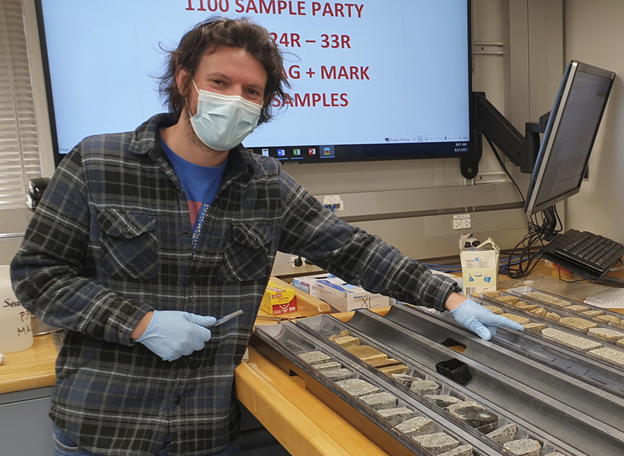
«Core-on-Deck»
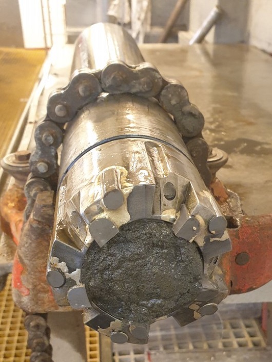
Det bores normalt 9,5 meter lange kjerneprøver om gangen. Disse kommer opp i et gjennomsiktig plastrør («liner»).
Vi henter opp 9,5 meter kjerne hver time, eller oftere, når vi borer grunne sedimenter. For basalter er borehastigheten mye lavere, og det tar gjerne 4 – 5 timer å få opp en kjerne.
Kjernene håndteres av IODP teknikere. De kuttes opp i 1,5 meter lange deler før de blir scannet, delt i to, beskrevet og analysert i laboratoriene på båten.
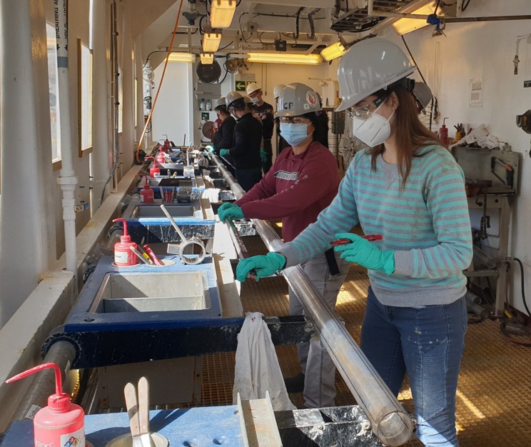 Foto: Sverre Planke
Location:
Hole U1570A (65°49.8901′N, 1°59.6225′E; water depth 2196.1 mbsl; proposed Site VMVM-56A)
Hole U1570B (65°49.6788′N, 1°57.3605′E; water depth 2270.9 mbsl; proposed Site VMVM-56A)
Science Update: Today we completed rotary coring in Hole U1570A, from 142.1 mbsf (Core U1570A-25R), to a final depth of 200 mbsf (Core 36R). The total recovery for the hole was 98.59 m (49%). After coring was completed at 1045 h, we raised the drill bit out of the hole to a depth of 2153.7 mbsl, at 1230 h. We moved in DP mode to Hole U1570B, along the approved ribbon line for Site U1570. We picked up the top drive and conducted routine rig servicing. After positioning the ship over the new hole coordinates, we spaced out the bit above the seafloor, lowered an RCB core barrel, and started rotary coring in Hole U1570B, at 1610 h, at a PDR depth of 2270.9 mbsl. We recovered Cores U1570B-1R to 6R (46.6 mbsf) with a recovery of 18 m (38%).
Today we measured and described Cores U1570A-12R to 30R. They consist of gray to very dark gray claystone with silt and sand, often laminated, and with occasional microfault structures. Black ash beds are common throughout. Glendonite is observed at three stratigraphic levels, and trace mollusks are present in Cores U1570A-29R and 30R.
The scientists continued to collect and analyze data from Sites U1569 and U1570, and prepared site reports.
31. august
Location: Hole U1570A (65°49.8901′N, 1°59.6225′E; water depth 2196.1 mbsl; proposed Site VMVM-56A)
Science Update: We started the day while lowering the drill pipe to begin rotary coring in Hole U1570A. At 0515 h, we picked up the top drive and adjusted the drill string length to position the bit for taking the first core. We started the hole at 0620 h and continued coring, deepening the hole to 142 mbsf by midnight (Cores U1570A-1R to 24R). Cores 1R to 6R (0–54.5 mbsf) were cut using full-length advances and retrieved only 19.29 m (35%). To improve core recovery, we switched to cutting half-length RCB cores from Core 7R on. The total material recovered between 54.5 and 142 mbsf was 44.6 m (51%).
Today we measured and described Cores U1570A-1R to 11R. Cores 1R to 6R consist of brown to olive gray clay with silt, with sand-rich and foraminifera-rich intervals. Cores 7R to 11R-CC consist of alternating layers of laminated black siltstone and ash. Core 11R is estimated to be of early Eocene age.
The scientists continued to collect and analyze data from Sites U1568 to U1570 and prepare site reports.
30. august
Oppdatering fra Co-Chief Scientist Sverre Planke (VBPR/CEED):
Drilling is going steadily ahead on the JR. We have now started drilling on the Mimir High, and plan to stay here for up to 10 days.
The drilling of the hydrothermal vent complex on the Modgunn Arch went very well. We completed five holes along a 500 m transect extending from the outer to the inner part of the vent, with >500 m core recovery. The two deepest holes were also logged with conventional and FMS imaging logs.
Drilling locations and targets where constrained by the the initial coring results. Palynology and high-resolution 3D P-Cable data were specifically useful to optimize the drilling transect.
We have recovered numerous ash layer and typical Paleocene-Eocene Thermal Maximum (PETM) microfossils, like A. Augustum and diatoms. Several holes terminated in older Paleocene mudstones, confirming the thickness variations of the crater infill.
 «Morgenstemning i Norskehavet under COVID-19-regime». Forrige uke markerte slutten på fem uker med karanteneregler, og alle på boreskipet kan fra nå av leve mer normalt. Foto: Sverre Planke
Location:
Hole U1569A (65°49.8775′N, 2°1.6081′E; water depth 2171.2 mbsl; proposed Site VMVM-55B)
Hole U1570A (65°49.8901′N, 1°59.6225′E; water depth 2196.1 mbsl; proposed ribbon Site VMVM-56A)
Science Update: Today we completed rotary coring operations in Hole U1569A after reaching our scientific target and penetrating 50 m into the late Paleocene with Core U1569A-44R at 404.6 mbsf. The total amount of core recovered at Hole U1569A is 144.9 m (36%). Following the retrieval of the last core at 0320 h, we secured the coring tools and began preparations for wireline logging. We conducted a 50-barrel high viscosity mud sweep to clean the hole and then lowered the RST and released the bit at the bottom of the hole. We then displaced the hole with 125 barrels of 10.5 ppg mud, raised the drill string, and set the end of the pipe at 84 mbsf. The triple combo tool string was rigged up and lowered through the pipe, but we were unable to pass beyond 127.6 mbsf with the bottom of the tool.
After trying repeatedly to clear and pass the obstruction, we ended logging operations and pulled the tool string back to the rig floor at 1400 h. We rigged down the logging tools, cleared the rig floor, and pulled back the end of the pipe out of the seafloor at 1554 h. We conducted required routine rig servicing (drill line slip and cut) and continued to raise the drill pipe back on board. At 1805 h, with the end of the pipe at 172 mbrf, we started a transit in DP mode to our next site, U1570 (proposed site VMVM-56A).
We covered the 1514 m distance in 2.5 h and arrived over the site coordinates at 2038 h. We finished retrieving the remainder of the drill pipe at 2220 h, ending Hole U1569A. We spent the rest of the day making up a new BHA with a mechanical bit release and deployed it to 172.1 mbrf by midnight.
Cores U1569A-36R to 44R consists of very dark gray claystone with silt, with occasional ash beds and early diagenetic pyrite. Laminations and small-scale fault structures are also present.
The scientists continued to collect and analyze data from Sites U1568 and U1569, and prepare site reports.
29. august
Location: Hole U1569A (65°49.8775′N, 2°1.6081′E; water depth 2171.2 mbsl; proposed Site VMVM-55B)
Science Update: We continued RCB coring in Hole U1569A through Core U1569A-43R to 400.9 mbsf. Total core recovered so far for Hole U1569A is 139.3 m (35.6%).
Cores U1569A-15R to 19R mainly consist of grayish-brown to very dark gray clay with silt and sand. Glendonite is present in Core 19R. Cores 20R to 36R mainly consist of very dark gray claystone, sometimes with parallel laminations that alternate with gray to black thin ash beds, which sometimes have a fining upward structure. Slight to moderate bioturbation is present in parts of the interval. Cores 20R to 22R, 26R to 28R, and 34R to 35R are marked by dewatering structures. The base of Core 38R is estimated to be of late Paleocene age.
The scientists are collecting and measuring data from Sites U1568 and U1569 and preparing site reports.
28. august
Location: Hole U1569A (65°49.8775′N, 2°1.6081′E; water depth 2171.2 mbsl; proposed Site VMVM-55B)
Science Update: The day started while lowering the pipe to start rotary coring in Hole U1569A. At 0130 h we picked up the top drive, adjusted the drill string length to position the bit for taking the first core, and started the hole at 0245 h. We continued RCB coring all day, deepening the hole to 234.3 mbsf by midnight. A total of 24 cores were cut (Cores U1569A-1R to 24R), recovering 98.4 m or 42%.
The cores described today (U1569A-1R to 14R) consist of brown to grayish brown, gray to very dark gray, and greenish gray clay with silt. The base of the described interval appears to be Miocene/Oligocene in age.
The Co-Chief Scientists presented the scientific objectives and operations plan for Site U1569. The scientists are collecting data, measuring samples from Sites U1568 and U1569, and preparing site reports.
27. august:
Oppdatering fra Co-Chief Scientist Sverre Planke:
Vi er veldig fornøyde med resultatene til nå; det er på alle måter bedre geologi/stratigrafi/recovery enn ventet.
Vi ble ferdig med siste hull på Modgunn for en time siden.
Neste hull er Mimir – det blir veldig spennende. Målet er få en god PETM seksjon, men det er jo som alltid usikkerheter i forhold til seismisk tolkning. P-Cable dataene fra i fjor (CAGE20-4) er veldig gode og ekstremt viktige for å detaljplanlegge boringene.
Bildet over: JOIDES Resolution har avsluttet boringene på Modgunn. Fem borehull på 85 til 200 meter dype ble boret, til sammen 710 meter.
543 meter borekjerner ble hentet opp som primært bestod av leire, leirstein og askelag. Alderen spenner fra kvartær til midtre paleocen, inkludert et mulig PETM-intervall.
Høyoppløselig 3D P-Cable seismiske data samlet under fjorårets CAGE20-4 tokt (Bünz et al., 2020)
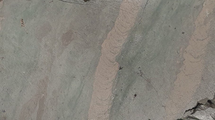
 Borekrone fylt med sandig leire fra Modgunnområdet. Foto: Sverre Planke
 Bioturbasjon: Leirstein med gravespor fra Modgunnområdet. Foto: Sverre Planke
Co-Chief Scientist Sverre Planke and Organic Geochemist Morgan Jones have written a blog post for our readers.
A global warming event 56 million years ago was likely caused by a large release of CO2 to the atmosphere. Was widespread volcanism in the North Atlantic the source?
Read more: Did volcanism cause the hothouse climate?
Location:
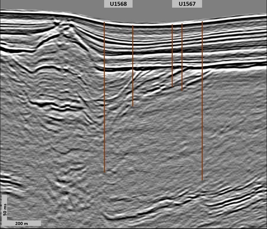
Hole U1567C (65°21.7848′N, 3°3.2193′E; water depth 1706.1 mbsl; proposed Site VMVM-31A)
Hole U1569A (65°49.8774′N, 2°1.6081′E; water depth 2171.2 mbsl; proposed Site VMVM-55B)
Science Update: Today we completed APC/XCB coring in Hole U1567C at 0845 h. Cores U1567C-4X to 14X extended the hole from 18.81 to 106.0 mbsf, recovering 48.66 m of core (83.6%). We retrieved the drill string, disassembled it, laid out all the components, and cleaned and secured the rig floor for transit. After raising the thrusters, we got underway to Site U1569 (proposed Site VMVM-55B) at 1345 h. We completed the short 38 nmi transit in 4.25 h, and positioned the ship over the site coordinates by 1800 h. We made up the BHA and began to deploy the drill string, reaching 2049 mbrf by midnight.
In Hole U1568B, Cores 11X to 14X-3 mainly consist of very dark greenish gray clay-rich siltstone with parallel laminations. Cores 14X-3 to 17X mainly consist of very dark to dark greenish gray siltstone with clay, with moderate to high bioturbation.
In Hole U1567C, Cores 2H to 4X-1 mainly consist of gray to yellow to greenish gray clay with varying amounts of sand and silt. Cores 4X-1 to 7X-1 mainly consists of gray to very dark gray siltstone with varying amounts of clay and sand. Cores 7X-2 to 11X mainly consist of very dark gray laminated claystone and occasional black sand beds. Cores 12X–14X consist of dark greenish gray claystone with silt and with moderate bioturbation. Two stratigraphic levels in Cores 10X and 11X potentially contain glendonite.
The scientists met to present and discuss the results from Sites U1565 and U1566, and continue to describe the core lithologies, measure core and interstitial water samples, and work on site reports.
25. august
Les vår sak: Tester klimahypotese på Modgunn 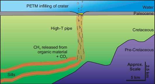 Konseptuell skisse av metanutslipp forårsaket av vulkansk aktivitet. Hypotesen om gassutslipp skal testes blant annet ved boringene på Modgunn.
 Den siste uken har forskerne nytt godt av meksikansk mat på menyen. Foto: Sandra Herrmann, IODP JRSO
Location:
Hole U1568A (65°21.5942′N, 3°3.1091′E; water depth 1704.4 mbsl; proposed Site VMVM-40B)
Hole U1568B (65°21.6630′N, 3°3.1540′E; water depth 1706.1 mbsl; proposed Site VMVM-40B)
Science Update: After coring was completed at 0030 h, we conditioned the hole for downhole logging by conducting a 50-barrel high viscosity mud sweep through the hole to clear the cuttings and then displaced the hole with 84 barrels of 10.5 ppg mud. We raised the end of the pipe to a logging depth of 82 mbsf, rigged up the triple combo tool string, and lowered it through the pipe, but it was unable to pass through the outer core barrel after several attempts.
The tool string was brought back to the surface at 0830 h, rigged down and inspected, and all its components verified to be in good condition. We then picked up the top drive, dropped an XCB core barrel, and circulated to verify that the barrel was landed. As everything seemed to be in good order, we retrieved the core barrel by wireline, rigged up the triple combo once again, and lowered it into the hole at 1200 h. This time, the tool string passed into the open hole without issue, reaching 188.7 mbsf on the first pass and 187.8 mbsf on the second pass.
We conducted two successful passes upwards, collecting magnetic susceptibility, resistivity, density (with caliper), neutron porosity, temperature, and natural gamma radiation data. The triple combo was retrieved at 1505 h and we rigged it down. Then we rigged up the FMS-sonic tool string and lowered it through the open hole. We successfully conducted two upward passes from 185.7 mbsf. The FMS-sonic tool was retrieved at 1945 h and the rig floor was cleared of all the logging equipment. We pulled up the pipe, clearing the seafloor at 2200 h, and ending Hole U1568A. After raising the pipe and setting the bit at 1677 mbrf, we moved 160 m to the north in DP mode to start Hole U1568B. We dropped an XCB wash barrel and dressed out the APC barrels in preparation for piston coring. Hole U1568B was spudded at midnight at a PDR depth of 1706.1 mbsl.
Cores U1568A-6H to 14X mainly consist of brownish yellow to brown clay with silt and gray to dark gray and black siltstone with various amounts of sand. Occasionally, organic matter, clasts, and nodules are present. Cores 15X to 17X are mostly very dark gray to very dark greenish gray sandstone with various amounts of clay and frequent occurrences of gravels and organic rich intervals.
Ash layers and lignite are also present. Cores 18X to 21X consist of very dark gray claystone with silt, sand, and gravels. Palynological analysis suggests an age of early Paleocene for the bottom of Hole U1568A.
The scientists continue to describe the core lithologies, measure core and interstitial water samples, and work on site reports.
Following 14 days of COVID-19 safety protocols at sea, measures were lifted at 1326 h.
24. august
Location: Hole U1568A (65°21.5942′N, 3°3.1091′E; water depth 1704.4 mbsl; proposed Site VMVM-40B)
Science Update: Today we completed APC/XCB coring of Hole U1568A to 200 mbsf. Piston cores U1568A-4H to 7H were taken from 22.9 to 51.7 mbsf with partial strokes recorded on Cores 6H and 7H. Core recovery was 29.73 m (102.5%) for this interval. In anticipation of a hard layer expected at ~60 mbsf and with the objective of improving core recovery through the interval, we deployed the XCB coring system with half-length advances for Cores 8X to 12X from 51.7 to 77.4 mbsf, collecting 25.05 m of core (97.5%). Then we switched to full XCB coring for Cores 13X to 21X from 77.4 to 165.3 mbsf. As core recovery dropped to ~40% in the last three cores, we switched back to half XCB advances to reach the total approved depth for the site (200 m) with Core 22X at midnight. In total, we obtained 53.22 m of core (102.9%) with the APC system and 102.1 m (71.6%) with the XCB system.
At Hole U1567B, Cores 5X to 11X contain greenish gray clay to dark gray claystone to very dark gray sand and siltstone. Some intervals show finely laminated black claystone with frequent occurrence of thin ash beds.
At Hole U1568A, Cores 1H to 5H contain greenish gray to grayish brown to very dark gray clay with varying amounts of silt and sand and occasional occurrence of pebbles. Palynological analysis suggests that Core U1568A-17X is of late Paleocene age.
The scientists continue to describe the core lithologies, measure core and interstitial water samples, and work on site reports.
Shipboard COVID-19 safety protocols continue to be followed onboard.
23. august
Location:
Hole U1567A (65°21.8514′N, 3°3.2562′E; water depth 1703.2 mbsl; proposed Site VMVM-31A)
Hole U1567B (65°21.7683′N, 3°3.2083′E; water depth 1704.3 mbsl; proposed Site VMVM-31A)
Hole U1568A (65°21.5942′N, 3°3.1091′E; water depth 1704.4 mbsl; proposed Site VMVM-40B)
Science Update: We started the day recovering the triple combo logging tool back to the surface, rigging up the FMS-sonic tool, and lowering it into the hole, where it reached 196.5 mbsf at 0130 h. We conducted two successful passes of the open hole before retrieving the tool back to the surface at 0500 h. After rigging down all logging equipment, we raised the drill pipe out of the hole at 0640 h and placed the bit at 1667 mbrf, ending Hole U1567A. Under DP mode, we moved the ship 165 m to the south along the seismic line between Site U1567 and the next site, U1568 (proposed site VMVM-40B), to start Hole U1567B. The objective of coring a second hole at this site was to attempt to sample an interval between 50–70 mbsf, that was not recovered in Hole U1567A.
We picked up the top drive, made up and dropped an XCB wash barrel, and rotary drilled without recovery to 25 mbsf in Hole U1567B. At 0820 h, we retrieved the wash barrel and then ran into the hole with an APC core barrel. APC coring (Cores U1567B-2H to 4H) deepened the hole to 49.3 mbsf with a recovery of 102.2%. At that point we switched to the XCB coring system and began to cut half cores to improve the chances of fully recovering the missing interval. We cored with the XCB system from 49.3 to 83.0 mbsf (Cores U1567B-5X to 11X) and recovered 30.45 m (90.4%). We pulled the drill string out of the hole, ending Hole U1567B at 1900 h, and set the bit at 1686.7 mbrf for DP transit to the next site.
The vessel was positioned over the Site U1568 coordinates, and the rig floor was cleared for operations at 1936 h. We spaced out the bit, dropped an APC core barrel, and attempted to start Hole U1568A at 1705 mbrf, based on a depth estimate from the PDR, but the first attempt at the mudline core did not recover any sediment. We lowered the bit to 1710 mbrf and started Hole U1568A at 2132 h. The mudline core recovered 3.89 m of sediment, making the calculated water depth 1704.4 mbsl. We continued APC coring through Core U1568A-3H to a depth of 22.9 mbsf before midnight.
In the laboratories, Cores U1567A-13X to 23X contain moderate to highly bioturbated dark greenish gray claystone with varying amounts of silt and sand, and occasional nodules or clasts. Palynological analysis estimates the age of the base of Core U1567A-20X in the early Paleocene.
The scientists continued to describe the core lithologies, measure core and interstitial water samples, and work on the Site U1565 and U1566 reports.
Shipboard COVID-19 safety protocols continue to be followed onboard.
22. august
Oppdatering fra Co-chief Scientist Sverre Planke (VBPR/CEED):
The two Kolga sites have now been completed. With very exciting results.
In short, we drilled thin Neogene clay above a c. 125 m thick sequence of basalt flows and interbedded meter-thick sediments/sandstone, before going into c. 35 m of weathered granitic rocks and sandstones. The recovery has been very good, up to 90% in some of the lava sequences. Some of it looks like the Rosebank cores.
Very extensive petrophysical data and wireline log data (image logs, sonic logs, VSP etc.) were collected in the basalt sequence.
We have now been at Modgunn for almost one day, drilling the reference site 31A.
Rosebank er et olje- og gassfelt vest for Shetland (Færø-Shetland-bassenget) som ligger over et annet oljefelt – Lochnagar. Rosebanks reservoarer er silisiklastiske lag som ligger mellom basaltlagene.
Tilstedeværelsen av magmatiske bergarter i et basseng/region (som Nord-Atlanteren) har stor betydning for modning, migrasjon og akkumulasjon av hydrokarboner.
I denne artikkelen kan du lese seks gode grunner for et leteselskap å rette fokuset mot slike områder. Der forteller John Millett (VBPR UK, avbildet under) hvorfor vi ikke kjenner til kommersielle sub-basaltfunn på norsk sokkel.
 John Millett (VBPR UK) analyserer de ferske kjernene som er hentet opp fra Kolga-høyden. Foto: Sverre Planke
Location: Hole U1567A (65°21.8514′N, 3°3.2562′E; water depth 1703.2 mbsl; proposed Site VMVM-31A)
Science Update: Coring continued throughout the day. Cores U1567A-5H to 23X were taken from 33.9 mbsf to a final depth of 195.9 mbsf. Full piston coring stopped after a partial stroke on Core U1567A-6H and we switched to the half-length advanced piston corer (HLAPC). Core U1567A-7F advanced only 1.2 m when it hit a hard layer at 54.1 mbsf (1.14 m recovery). We then deployed the XCB coring system with half-length advances for Cores 8X–10X to try to improve recovery. As recovery improved, we switched to XCB coring with full advances for Cores 11X (64.5 mbsf) to 23X (195.9 mbsf). In total, 181.58 m of core (92.7%) were recovered from Hole U1567A.
After coring was completed, we conditioned the hole for downhole logging. We conducted a 50-barrel high viscosity mud sweep, then displaced the hole with 85 barrels of 10.5 ppg mud, and raised the end of the pipe to a logging depth of 82.8 mbsf. After a safety logging meeting with the Schlumberger engineer, we rigged up the triple combo tool string and tested it. We lowered it downhole to 196.5 mbsf at 2105 h and collected data over two successful passes through the open hole by midnight.
Cores U1567A-1H to 6H contain yellowish-brown to olive green clay with varying amounts of silt and sand. Cores U1567A-7F to 9X contain very dark gray sand, sandstone, and gravel. Cores 10X to 12X contain dark greenish gray siltstone and claystone. The base of Core U1567A-9X is estimated to be 55 My old based on dinocyst biomarkers. No calcareous microfossils have been found below Core 2H (14.9 mbsf).
The scientists continue to describe the core lithologies, measure core and discrete samples for geochemical, petrophysical and magnetic properties, and work on the Site U1565 and U1566 reports.
Shipboard COVID-19 safety protocols continue to be followed onboard.
21. august
Location:
Hole U1566A (64°57.8869′N, 2°43.7533′E; water depth 2099.2 mbsl; proposed Site VMVM-23A)
Hole U1567A (65°21.8514′N, 3°3.2562′E; water depth 1703.2 mbsl; proposed Site VMVM-31A)
Science Update: We started the day conducting the second pass with the (UBI) tool. Measurements were collected successfully from 145 mbsf to the base of the pipe (50 mbsf), and the UBI was brought back to the surface at 0200 h. After rigging down all logging equipment, we raised the drill pipe, clearing the seafloor at 0335 h and the drill floor at 0630 h.
The BHA drill collar stands were set back, and all core barrel components were broken down, inspected, and laid out. The rig floor was secured for transit, the thrusters raised, and we started the short sea passage to Site U1567 (proposed Site VMVM-31A) at 0800 h. We arrived over the site coordinates at 1148 h, lowered the thrusters, and switched to DP mode. At 1208 h, the drill floor was cleared for operations.
A reading with the PDR estimated the water depth at 1699.1 mbsl. By 1800 h, we had made up the advanced piston corer/extended core barrel (APC/XCB) outer core barrel (OCB) and BHA and lowered the end of the drill pipe to 1655.7 mbsl. We picked up the top drive, spaced out the bit, and attempted to spud Hole U1567A from 1694.1 mbsl, but the APC core came up empty with only traces of mud in the cutting shoe. We lowered the bit 5 m and shot from 1699.1 mbsl.
This time, Core U1567A-1H returned 5.41 m of mud, providing an APC calculated water depth of 1703.2 mbsl. We continued APC coring through Core U1567A-4H to a depth of 33.9 mbsf by midnight.
Cores U1566A-28R to 33R (142.8–181.7 mbsf) contain aphyric basalt with vesicular variations and highly altered granite with biotite, locally decomposed to sandstone. The scientists continue to measure core and discrete samples for petrophysical and magnetic properties, and to work on the Site U1565 and U1566 reports.
Shipboard COVID-19 safety protocols continue to be followed onboard.
20. august
Location: Hole U1566A (64°57.8869′N, 2°43.7533′E; water depth 2099.2 mbsl; proposed Site VMVM-23A)
Science Update: After releasing the drill bit at the bottom of the hole, we set back the top drive and raised the end of the pipe to 50 mbsf at 0330 h in preparation for logging. The triple combo tool string was rigged up and lowered into the hole to 145 mbsf, where it encountered a borehole obstruction and could not pass after several attempts.
We conducted two successful passes upwards from 145 mbsf, collecting magnetic susceptibility, resistivity, density (with caliper), neutron porosity, temperature, and natural gamma radiation data. The triple combo was brought back to the surface by 0900 h. We rigged up the Versatile Seismic Imager (VSI) and lowered it to 145 mbsf for a vertical seismic profile experiment. We recorded a series of stations at 10 m intervals over 10–15 minutes per interval.
After retrieving the VSI tool back to the surface, we rigged up the Formation MicroScanner (FMS)-sonic tool and conducted two successful passes from 145 mbsf upwards to 50 mbsf. After retrieving and rigging down the FMS-sonic tool at 2100 h, we prepared the Ultrasonic Borehole Imager (UBI) tool and ran it to 145 mbsf. We conducted the first pass successfully, and the day ended while conducting a second pass.
Cores U1566A-20R to 27R (103.9–142.8 mbsf) contain alternating aphyric basalt with vesicular variations interbedded with sandstone, some of which contain granitic clasts. The scientists continue to describe the core lithologies, measure core and discrete samples for petrophysical and magnetic properties, and to work on the Site U1565 and U1566 reports.
Shipboard COVID-19 safety protocols continue to be followed onboard.
19. august
Boreskipet har hentet siste kjerneprøve fra Kolga-høyden og skal reise nordover til Modgunn-lokalitetene. Se kart og illustrasjoner over området her.
Fra boreskipets Twitter-side:
August 19, 2021, 22:59 UTC: Last core of this site. Next: logging.
Location: Hole U1566A (64°57.8869′N, 2°43.7533′E; water depth 2099.2 mbsl; proposed Site VMVM-23A)
Science Update: Cores U1566A-24R to 33R extended the hole from 123.6 mbsf to the final depth of 181.7 mbsf by 2230 h, recovering 28.4 m of core (49%). The total amount of core recovered at Hole U1566A was 100.5 m (55.2%). Following the retrieval of the last core, we began preparations for wireline logging.
A 50-barrel high viscosity mud sweep was conducted to clean the hole and then the hole was circulated with salt water. The day ended with lowering the rotary shifting tool (RST) to release the bit at the bottom of the hole.
Cores U1566A-15R to 19R (79.6–103.9 mbsf) yielded a succession of mostly aphyric basalt with variations in vesicularity. The scientists are working on the Site U1565 and U1566 reports.
Shipboard COVID-19 safety protocols continue to be followed onboard.
18. august
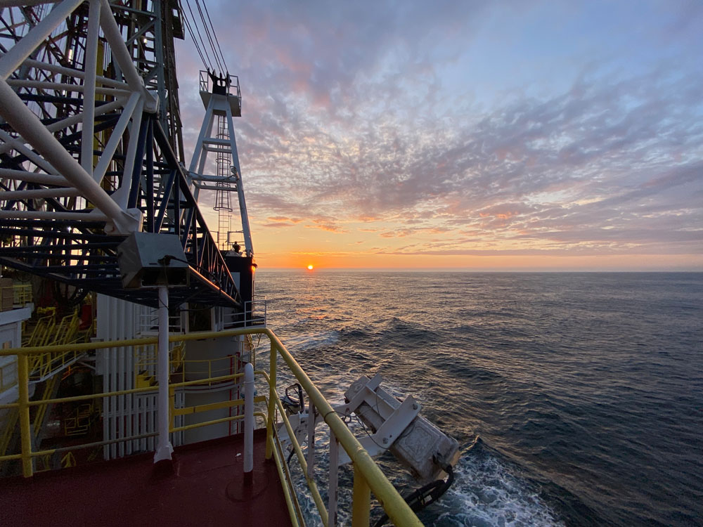 Foto: Sandra Herrmann
Location: Hole U1566A (64°57.8869′N, 2°43.7533′E; water depth 2099.2 mbsl; proposed Site VMVM-23A)
Science Update: Coring continued throughout the day. Cores U1566A-14R to 22R were taken from 74.7 to 118.6 mbsf with good recovery (30.5 m, 69.5%). The bit encountered a tight spot at 118.5 mbsf and the bit was moved up and down to clear the hole. We then cut and retrieved Core U1566A-23R from 123.6 mbsf (recovery 0.7 m, 14%) and continued coring.
Cores U1566A-10R to 14R (55.0–79.6 mbsf) yielded alternating lava flows consisting of aphyric basalt with variations in vesicularity. Some lava flows are separated by sandstones, some of which contain granitic clasts.
An organic rich layer with continental wood fragments was found interbedded between lava flows in Core U1566A-11R.
The pollen assemblage extracted from this layer indicates a late Paleocene–early Eocene age. The scientists are working on the Site U1565 reports.
Shipboard COVID-19 safety protocols continue to be followed onboard.
17. august
Oppdatering fra Co-chief Scientist Sverre Planke (VBPR/CEED):
We have completed the first three days of drilling on Kolga High, making good progress. The weather has been close to perfect with flat sea and plenty of sun. Peter took the drone out yesterday to document the conditions.
We spent one day drilling the sub-basalt basement window at the first site, recovering what looks like weathered granitic rocks. Details will be sorted out after analyzing thin sections and geochemistry.
Now we have been at the second site for almost two days, recovery great-looking basalts! Drilling is slow (typically 1 meter per hour), but the recovery is good. Our plans are to stay here for 4-5 days more before moving to the Modgunn sites.
Location: Hole U1566A (64°57.8869′N, 2°43.7533′E; water depth 2099.2 mbsl; proposed Site VMVM-23A)
Science Update: Coring continued throughout the day. Cores U1566A-8R to 13R were taken from 44.6 to 74.7 mbsf with good recovery (21.62 m, 71.8%).
Cores U1566A-5R to 9R (31.3–55.0 mbsf) yielded alternating lava flows consisting of aphyric and sparsely plagioclase phyric basalt with varying vesicularity. Sporadic volcanoclastic layers are interbedded between lava flows. Measurements of discrete core and pore water samples from Site U1565 were completed and the scientists are working on the Site U1565 reports.
Shipboard COVID-19 safety protocols continue to be followed onboard.
16. august
Update from Physical Properties Specialist/Downhole Measurements Peter Betlem (UNIS, UiO and NCCS):
So far so good; good vibes onboard and the expedition is going well.
We moved on to the second drill site after success at the first.
With great weather and bathtub-like seas, what more could we ask for?
 Dronefoto av boreskipet under svært gode vær- og bølgeforhold. Foto: Peter Betlem/Sverre Planke
Location:
Hole U1565B (64°57.8044′N, 2°44.8454′E; water depth 2070.4 mbsl; proposed Site VMVM-20A)
Hole U1566A (64°57.8869′N, 2°43.7533′E; water depth 2099.2 mbsl; proposed Site VMVM-23A)
Science Update: We completed rotary coring of Hole U1565B after cutting Core U1565B-5R from 30.7 to 31.7 meters below sea floor (mbsf), recovering 17 cm (17%) of granite confirming the lateral extent of the granite bed sampled in Hole U1565A. The drill bit was pulled up, clearing the seafloor at 0215 h, and ending Hole U1565B and the site. We raised the end of the pipe to 2020 m below the rig floor (mbrf) and transited to the next site, U1566 (proposed site VMVM-23A), under dynamic positioning (DP) navigation mode. After positioning the ship over the site’s coordinates, we spaced out the bit above the seafloor, lowered an RCB core barrel, and started Hole U1566A at 0525 h. The seafloor was tagged at 2099.2 meters below sea level (mbsl) and rotary coring began. Cores U1566A-1R to 7R advanced the hole from the seafloor to 44.6 mbsf, recovering 19.29 m (43.3%).
Cores U1565B-1R to 5R were measured for physical properties, split, and described. Cores U1565B-1R through 4R consist of greenish gray to brownish gray alternating clay, clay with silt, and sand, and dropstone-rich sand with clay. Core U1566B-5R sampled the same strongly weathered medium-grained granite found in Hole U1565A. Preliminary biostratigraphic examination reveals significant reworking in the cored sedimentary section, yielding a mix of Quaternary to Cretaceous microfossils and poor diatom and palynological preservation.
Cores U1566A-1R to 3R consist of clay and silt-rich clay with various amounts of sand and clasts. Cores U1566A-4R consists of phyric basalt.
Shipboard COVID-19 safety protocols continue to be followed onboard.
15. august
Oppdatering fra Co-chief Scientist Sverre Planke (VBPR/CEED):
Vi har nå flyttet oss til Site 23A etter å ha boret ferdig to hull på Site 20A.
JOIDES Resolution melder via Facebook at de første kjerneprøvene er hentet opp. Det ble blant annet påvist sterkt forvitret granitt i én av kjernene.
Target på 20A var «unknown basement» (sub-basalt). Alle på båten skrev opp hva de trodde vi kom til å treffe før boringene – og svarene varierte fra kaledonsk til tertiær alder og deformerte sedimenter – med eller uten intrusjoner – til gabbro, granitt og metaforft grunnfjell.
Uansett hva vi hadde boret ville det ha vært en overraskelse.
 Foto (video): Nick Logan / JRSO
 Toktets første kjerneprøve inneholdt forvitret granitt. Foto: Sandra Herrmann / JRSO
Location:
Hole U1565A (64°57.7619′N, 2°44.9892′E; water depth 2072.3 mbsl; proposed Site VMVM-20A)
Hole U1565B (64°57.8044′N, 2°44.8454′E; water depth 2070.4 mbsl; proposed Site VMVM-20A)
Science Update: We continued lowering the bit to the seafloor until 0245 h. We installed the top drive, adjusted the drill string length to position the bit for taking the first core, and pumped a pig through the drill string to clean out rust and any obstructions. We dropped a rotary core barrel (RCB) and attempted to start Hole U1565A at 2056.3 m below sea level (mbsl) based on a depth estimate from the precision depth recorder (PDR), but the first attempt at the mudline core did not recover any sediment.
We continued to lower the bit, tagging the seafloor at 2072.3 mbsl at 0515 h. Then we rotary cored Hole U1565A to 28 m below the seafloor (mbsf), obtaining 4.21 m of core (15% recovery). Coring was ended after Core U1565A-4R due to very slow penetration rates and confirming the lateral extent of a massive granitic unit obtained in this core. We pulled out of the hole and moved the ship 138 m WNW to start Hole U1565B.
After picking up the drilling knobby and spacing out the bit above the seafloor, RCB coring of Hole U1565B was initiated and continued for the rest of the day, cutting Core U1565B-5R at a depth of 30.5 mbsf at midnight. Recovery for Cores U1565B-1R to 4R was 15.28 m (49.8%). Cores U1565A-1R to 4R were measured for physical properties, split, and described.
Cores U1565A-1R through 3R consist of greenish gray to brownish gray clay, with graded beds of silt and sand, and varying amounts of calcareous nannofossils and planktonic foraminifera. Igneous and metamorphic dropstones are common. Core U1565A-4R consists of strongly weathered coarse-grained granite. Preliminary biostratigraphic examination suggests significant reworking. Shipboard COVID-19 safety protocols continue to be followed onboard.
14. august
Oppdatering fra Co-chief Scientist Sverre Planke (VBPR/CEED):
På plass og borekrone på vei ned. Vi har 50 dager på oss for å bli ferdige …
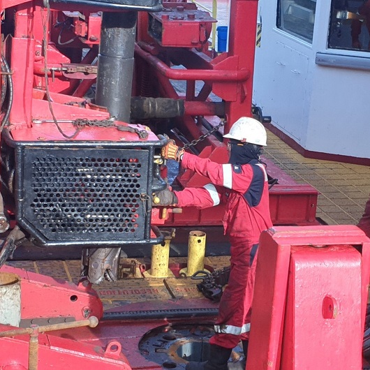 Photo: Sverre Planke
Location: Hole U1565A (64°57.7619′N, 2°44.9892′E; water depth 2083.4 mbsl; proposed Site VMVM-20A)
Science Update: After an 803 nmi transit, the ship arrived at Site U1565 (proposed Site VMVM-2A) at 1530 h. The thrusters were lowered, and the vessel switched to dynamic positioning (DP) mode, clearing the drill floor for operations.
The crew assembled the outer core barrel with a C-4 rotary core barrel (RCB) bit and the bottom-hole assembly (BHA), and started lowering the drill pipe to the seafloor, filling the pipe with seawater every 20 stands.
By the end of the day, the drill pipe had been deployed to 1327 m below the rig floor. Wind and sea conditions remained calm throughout the day.
13. august
Oppdatering fra Co-chief Scientist Sverre Planke (VBPR/CEED):
Etter planen er vi on-site i morgen.
Toktets første stopp er Kolga-høyden (Kolga High) der det etter planen skal bores ved to lokaliteter, målene er sub-basalt og initial basalt. Profilet under viser posisjonen til de to borehullene 20A og 23A på Kolga-høyden.
 Illustrasjon: IODP Scientific prospectus
Location: Underway to Site U1565
Science Update: The Co-Chief Scientists, Operations Superintendent, Schlumberger Logging Engineer, and Expedition Project Manager (EPM) met with the ship crew to review and confirm the planned coring and logging operations for the first five sites of the expedition.
The drilling plan is to start with Sites U1565 (proposed site VMVM-20A) and U1566 (VMVM-23A) on the Kolga High. The Co-Chief Scientists presented the background and objectives for these sites to the scientists, which are to sample and characterize the age and lithology of the subbasalt sequences and initial volcanic flows on the mid-Norwegian margin.
Weather and sea conditions are good. Our average speed for the day was 11.5 kt, and we have 178 nmi remaining to our first site. The estimated time of arrival at Site U1565 is ~1600 h on 14 August.
12. august
Update from Physical Properties Specialist/Downhole Measurements Peter Betlem (UNIS, UiO and NCCS):
We departed just after 1 pm local time yesterday, and have now hit the high seas where there’s quite a bit of swell.
We’ll be continuing the familiarization and calibration of the instruments over the next few hours/days before reaching the area of our first drill site.
 Photos: Peter Betlem
Location: Underway to Site U1565
Science Update: The Expedition 396 scientists continued training in the laboratories. The paleontology team received more detailed orientations on the core description application and microscope training. The JRSO technical staff reviewed the protected species observation protocol.
The first lifeboat drill was held in the morning. Shipboard COVID-19 safety protocols continue to be followed onboard. Weather and sea conditions are fair, with waves averaging 1.8 m in height and winds of 10 kt. Our average speed for the day was 9.6 kt, and we have 455 nmi remaining to our first site.
The estimated time of arrival at Site U1565 (proposed site VMVM-20A) is the evening of 14 August.
11. august
Location: Underway to Site U1565
Science Update: The final nine members of the Siem Offshore personnel boarded the vessel in the morning, and one person departed due to a medical condition. With the harbor pilot onboard at 1245 h, the ship left the dock after the last line was released at 1312 h.
The pilot departed at 1326 h, and the ship was underway to Site U1565 (proposed Site VMVM-20A) in the Norwegian Margin at 1400 h. The scientists received training on IODP sampling procedures and the core description application, and they continued to set up their laboratories. Shipboard COVID-19 safety protocols are being followed onboard.
10. august
Location: Berth 10 Scarfabakki, Reykjavík, Iceland
Science Update: Bunkering restarted at 0742 h and was completed at 1008 h with the loading of 1110 mt of fuel over two days. The food shipment and other catering supplies arrived and were loaded onboard and stored. Other port call activities included offloading of IODP airfreight and refrigerated shipments.
Laboratory training for new JRSO staff and scientists continued. Scientists were given core flow tours and introduced to laboratory instruments. Shipboard COVID-19 safety protocols are being followed and the ship is scheduled to depart Reykjavík at 1300 h on 11 August.
9. august
Location: Berth 10 Scarfabakki, Reykjavík, Iceland
Science Update: Port call activities continued for Expedition 396. The ship loaded 763.8 mt of fuel. JRSO staff and scientists continued laboratory setup and training, and received ship safety tours.
Shipboard COVID-19 safety protocols are being followed and the ship is tentatively scheduled to depart Reykjavík at 1300 h on 11 August.
8. august
Location: Berth 10 Scarfabakki, Reykjavík, Iceland
Science Update: The Expedition 396 scientists, JRSO staff and ship’s crew boarded the vessel in the morning and settled into their cabins. After lunch, all shipboard personnel cleared immigration formalities and the day shift scientists and new technicians received a general presentation on ship safety.
Scientists started to set up their computers to access the ship’s network and to learn their laboratories. Other port call activities included distribution of oncoming freight. Shipboard COVID-19 safety protocols are being followed and the ship is scheduled to depart Reykjavík on 11 August.
7. august
Location: Berth 10 Scarfabakki, Reykjavík, Iceland
Science Update: Port call activities continued with the loading and offloading of freight. The Expedition 396 scientists, JRSO staff, and ship’s crew continued to isolate in their hotel rooms in Reykjavík, following JRSO quarantine and COVID-19 testing procedures prior to boarding on 8 August.
Virtual orientation and preparation meetings continued with the scientists receiving introductions on core curation and sampling, and drilling and coring operations. Laboratory teams continued to work on their Methods chapters and discuss their sampling and measuring plans for the expedition. The ship is scheduled to depart Reykjavík on 11 June.
6. august
Location: Berth 10 Scarfabakki, Reykjavík, Iceland
Science Update: Mid-Norwegian Continental Margin Magmatism Expedition 396 officially began in Reykjavík, Iceland, at 0842 h on 6 August 2021 upon arrival of the JOIDES Resolution at the end of Expedition 395C. The Expedition 395C offgoing personnel received a COVID test, underwent immigration procedures, and began port call activities.
All oncoming Expedition 396 personnel, including a reduced JRSO and scientific team, arrived five days earlier to Reykjavík and are following preboarding COVID-19 protocols. These included a two-week shelter-in-place period prior to travel, a pretravel COVID-19 test, and a seven-day quarantine in a hotel in Reykjavík, with two additional COVID-19 tests, prior to boarding the vessel on 8 August.
Taking advantage of the quarantine in the hotel, the Expedition 396 scientists and JRSO staff began virtual expedition preparation and received orientations to life on board the JOIDES Resolution (including our JRSO Code of Conduct), and laboratory safety training, including hydrofluoric acid (HF) usage and safety, and radiation training protocols.
During the week, the laboratory teams continued to draft their Methods chapters and the shipboard sampling plans for the expedition. The ship is scheduled to depart Reykjavík on 11 August. 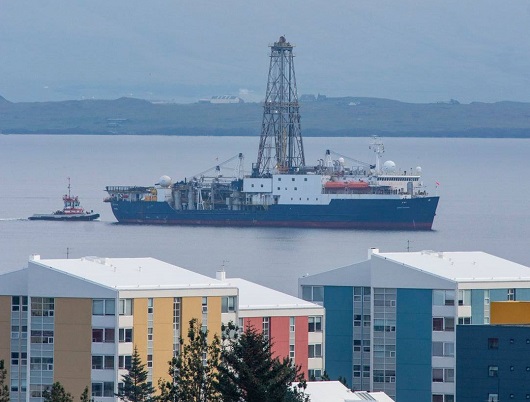 Boreskipet ankom Reykjavik 6. august. Foto: Carlos Zarikian / JOIDES Resolution
")